Khetri geodata
Khetri (Rajasthan) is a populated place; located in India in Asia/Kolkata (GMT+5.5) time zone. With population of 17,177 people, there are 2268 cities with bigger population in this country. Compared to other cities in India, 84.4% of cities are located further ↓South; 75.9% of cities are located further →East and 75.9% of cities have lower elevation than Khetri. Note1


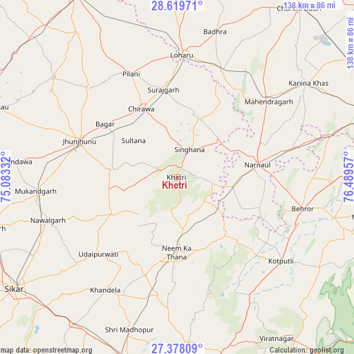
Khetri GPS coordinates[2]
28° 0' 2.484" North, 75° 47' 11.184" East
| Map corner | latitude | longitude |
|---|---|---|
| Upper-left | 28.61971°, | 75.08332° |
| Center: | 28.00069°, | 75.78644° |
| Lower-right: | 27.37809°, | 76.48957° |
| Map W x H: | 138.1×138.1 km | = 85.8×85.8mi |
| max Lat: | 34.9274° ⇑15.6% North |
| Khetri: | 28.00069° |
| min Lat: | ⇓84.4% South 8.09008° |
| min Long | Khetri | max Long |
| 68.82655° | 75.78644° | 96.81° |
| W 24.1%⇐ | ⇒75.9% E |
Elevation
Elevation of Khetri is 398 m = 1306 ft, and this is 102.4 m = 336 ft above average elevation for this country.
| Max E: |
3681 m = 12077 ft | 24.1% |
| Khetri | 398 m 1306 ft | |
| Avg. | 295.6 m = 970 ft | |
Min E: |
1 m = 3 ft | 75.9% |
See also: India elevation on elevation.city.
Geographical zone
Khetri is located in North temperate zone (between Tropic of Cancer and the Arctic Circle). Distance of this Northern Tropic circle is 507.5 km =315.3 mi to South.| Distance of | km | miles | from Khetri |
|---|---|---|---|
| North Pole | 6893.7 | 4283.5 | to North |
| Arctic Circle | 4287.8 | 2664.3 | to North |
| Tropic Cancer | 507.5 | 315.3 | to South |
| Equator | 3113.4 | 1934.6 | to South |


Nearby cities:
15 places around Khetri: (largest is in red/bold)
• Ateli Mandi
47.8 km =29.7 mi,  76°
76°
• Bagar
35 km =21.7 mi,  306°
306°
• Behror
50.2 km =31.2 mi,  104°
104°
• Chidawa
30.2 km =18.8 mi,  331°
331°
• Jhunjhunūn
40.6 km =25.2 mi,  290°
290°
• Khandela
52.1 km =32.4 mi,  212°
212°
• Kotputli
52.4 km =32.6 mi,  129°
129°
• Lohāru
47.8 km =29.7 mi,  2°
2°
• Mahendragarh
46.7 km =29 mi,  50°
50°
• Nawalgarh
53 km =32.9 mi,  251°
251°
• Neem ka Thana
29 km =18 mi,  179°
179°
• Nārnaul
32 km =19.9 mi, 81°
• Pilāni
44.5 km =27.7 mi,  336°
336°
• Sūrajgarh
34.8 km =21.6 mi,  351°
351°
• Udaipur
43.7 km =27.2 mi,  225°
225°
Sources, notices
• [Note1] Compared only with cities in India existing in our database
• [Src1] Map data: © OpenStreetMap contributors (CC-BY-SA)
• [Src2] Other city data from geonames.org with taken over terms of usage.
• [Src3] Geographical zone / Annual Mean Temperature by Robert A. Rohde @ Wikipedia
