Bāghpat geodata
Bāghpat (Uttar Pradesh) is a populated place; located in India in Asia/Kolkata (GMT+5.5) time zone. With population of 41,766 people, there are 1056 cities with bigger population in this country. Compared to other cities in India, 88.9% of cities are located further ↓South; 60.9% of cities are located further →East and 55.1% of cities have lower elevation than Bāghpat. Note1


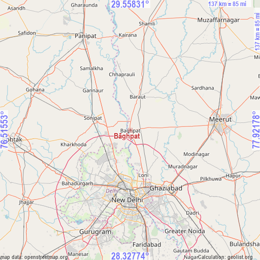
Bāghpat GPS coordinates[2]
28° 56' 41.46" North, 77° 13' 7.14" East
| Map corner | latitude | longitude |
|---|---|---|
| Upper-left | 29.55831°, | 76.51553° |
| Center: | 28.94485°, | 77.21865° |
| Lower-right: | 28.32774°, | 77.92178° |
| Map W x H: | 136.8×136.8 km | = 85×85mi |
| max Lat: | 34.9274° ⇑11.1% North |
| Bāghpat: | 28.94485° |
| min Lat: | ⇓88.9% South 8.09008° |
| min Long | Bāghpat | max Long |
| 68.82655° | 77.21865° | 96.81° |
| W 39.1%⇐ | ⇒60.9% E |
Elevation
Elevation of Bāghpat is 227 m = 745 ft, and this is 68.6 m = 225 ft below average elevation for this country.
| Max E: |
3681 m = 12077 ft | 44.9% |
| Avg. | 295.6 m = 970 ft | |
| Bāghpat | 227 m = 745 ft | |
Min E: |
1 m = 3 ft | 55.1% |
See also: Bāghpat elevation on elevation.city.
Geographical zone
Bāghpat is located in North temperate zone (between Tropic of Cancer and the Arctic Circle). Distance of this Northern Tropic circle is 612.4 km =380.5 mi to South.| Distance of | km | miles | from Bāghpat |
|---|---|---|---|
| North Pole | 6788.7 | 4218.3 | to North |
| Arctic Circle | 4182.8 | 2599.1 | to North |
| Tropic Cancer | 612.4 | 380.5 | to South |
| Equator | 3218.4 | 1999.8 | to South |


Nearby cities:
15 places around Bāghpat: (largest is in red/bold)
• Alīpur
18.3 km =11.4 mi,  207°
207°
• Baraut
18 km =11.2 mi,  13°
13°
• Bawāna
24.2 km =15 mi,  227°
227°
• Chhaprauli
29.8 km =18.5 mi,  351°
351°
• Delhi
32.6 km =20.3 mi,  177°
177°
• Karol Bāgh
32.7 km =20.3 mi, 184°
• Kharkhauda
30.9 km =19.2 mi,  256°
256°
• Khekra
10.9 km =6.8 mi,  144°
144°
• Loni
22.6 km =14 mi,  162°
162°
• Murādnagar
32.8 km =20.4 mi,  123°
123°
• Narela
16 km =9.9 mi, 230°
• Niwāri
32 km =19.9 mi,  103°
103°
• Pitampura
29.6 km =18.4 mi,  196°
196°
• Rohini
26.8 km =16.7 mi, 213°
• Sonīpat
20.2 km =12.6 mi,  285°
285°
Sources, notices
• [Note1] Compared only with cities in India existing in our database
• [Src1] Map data: © OpenStreetMap contributors (CC-BY-SA)
• [Src2] Other city data from geonames.org with taken over terms of usage.
• [Src3] Geographical zone / Annual Mean Temperature by Robert A. Rohde @ Wikipedia
