Sonepur geodata
Sonepur (Odisha) is a populated place; located in India in Asia/Kolkata (GMT+5.5) time zone. With population of 18,768 people, there are 2147 cities with bigger population in this country. Compared to other cities in India, 62.3% of cities are located further ↑North; 81.8% of cities are located further ←West and 67.4% of cities have higher elevation than Sonepur. Note1


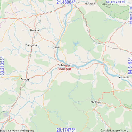
Sonepur GPS coordinates[2]
20° 49' 59.988" North, 83° 55' 0.012" East
| Map corner | latitude | longitude |
|---|---|---|
| Upper-left | 21.48904°, | 83.21355° |
| Center: | 20.83333°, | 83.91667° |
| Lower-right: | 20.17475°, | 84.6198° |
| Map W x H: | 146.1×146.1 km | = 90.8×90.8mi |
| max Lat: | 34.9274° ⇑62.3% North |
| Sonepur: | 20.83333° |
| min Lat: | ⇓37.7% South 8.09008° |
| min Long | Sonepur | max Long |
| 68.82655° | 83.91667° | 96.81° |
| W 81.8%⇐ | ⇒18.2% E |
Elevation
Elevation of Sonepur is 105 m = 344 ft, and this is 190.6 m = 625 ft below average elevation for this country.
| Max E: |
3681 m = 12077 ft | 67.4% |
| Avg. | 295.6 m = 970 ft | |
| Sonepur | 105 m = 344 ft | |
Min E: |
1 m = 3 ft | 32.6% |
See also: India elevation on elevation.city.
Geographical zone
Sonepur is located in North Torrid zone (between Equator and Tropic of Cancer). Distance of this Northern Tropic circle is 289.5 km =179.9 mi to North.| Distance of | km | miles | from Sonepur |
|---|---|---|---|
| North Pole | 7690.6 | 4778.7 | to North |
| Arctic Circle | 5084.7 | 3159.5 | to North |
| Tropic Cancer | 289.5 | 179.9 | to North |
| Equator | 2316.4 | 1439.3 | to South |


Nearby cities:
15 places around Sonepur: (largest is in red/bold)
• Balāngīr
46.6 km =29 mi,  252°
252°
• Bargarh
63.6 km =39.5 mi,  330°
330°
• Barpāli
52.4 km =32.6 mi,  319°
319°
• Baud
42.6 km =26.5 mi,  89°
89°
• Binka
24.1 km =15 mi, 333°
• Burla
75.4 km =46.9 mi,  356°
356°
• Hīrākud
77 km =47.8 mi, 356°
• Kaintragarh
65.5 km =40.7 mi,  100°
100°
• Padampur
90.5 km =56.2 mi,  281°
281°
• Patnāgarh
82.7 km =51.4 mi,  260°
260°
• Phulbāni
51 km =31.7 mi,  140°
140°
• Rengāli
91.5 km =56.9 mi,  8°
8°
• Sambalpur
70.5 km =43.8 mi,  4°
4°
• Tarabha
27.6 km =17.1 mi, 246°
• Udayagiri
91.8 km =57 mi,  149°
149°
Sources, notices
• [Note1] Compared only with cities in India existing in our database
• [Src1] Map data: © OpenStreetMap contributors (CC-BY-SA)
• [Src2] Other city data from geonames.org with taken over terms of usage.
• [Src3] Geographical zone / Annual Mean Temperature by Robert A. Rohde @ Wikipedia
