Phulbāni geodata
Phulbāni (Odisha) is a populated place; located in India in Asia/Kolkata (GMT+5.5) time zone. With population of 36,613 people, there are 1198 cities with bigger population in this country. Compared to other cities in India, 63.7% of cities are located further ↑North; 82.5% of cities are located further ←West and 81.5% of cities have lower elevation than Phulbāni. Note1


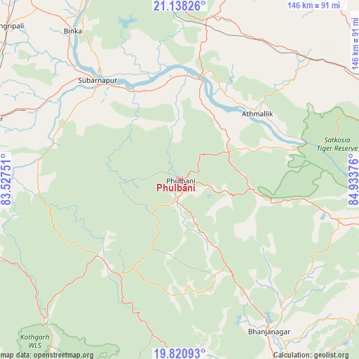
Phulbāni GPS coordinates[2]
20° 28' 51.636" North, 84° 13' 50.268" East
| Map corner | latitude | longitude |
|---|---|---|
| Upper-left | 21.13826°, | 83.52751° |
| Center: | 20.48101°, | 84.23063° |
| Lower-right: | 19.82093°, | 84.93376° |
| Map W x H: | 146.5×146.5 km | = 91×91mi |
| max Lat: | 34.9274° ⇑63.7% North |
| Phulbāni: | 20.48101° |
| min Lat: | ⇓36.3% South 8.09008° |
| min Long | Phulbāni | max Long |
| 68.82655° | 84.23063° | 96.81° |
| W 82.5%⇐ | ⇒17.5% E |
Elevation
Elevation of Phulbāni is 482 m = 1581 ft, and this is 186.4 m = 612 ft above average elevation for this country.
| Max E: |
3681 m = 12077 ft | 18.5% |
| Phulbāni | 482 m 1581 ft | |
| Avg. | 295.6 m = 970 ft | |
Min E: |
1 m = 3 ft | 81.5% |
See also: India elevation on elevation.city.
Geographical zone
Phulbāni is located in North Torrid zone (between Equator and Tropic of Cancer). Distance of this Northern Tropic circle is 328.6 km =204.2 mi to North.| Distance of | km | miles | from Phulbāni |
|---|---|---|---|
| North Pole | 7729.8 | 4803.1 | to North |
| Arctic Circle | 5123.9 | 3183.8 | to North |
| Tropic Cancer | 328.6 | 204.2 | to North |
| Equator | 2277.3 | 1415 | to South |


Nearby cities:
15 places around Phulbāni: (largest is in red/bold)
• Angul
99.1 km =61.6 mi,  66°
66°
• Balāngīr
81 km =50.3 mi,  287°
287°
• Baud
40.9 km =25.4 mi,  14°
14°
• Belaguntha
79 km =49.1 mi,  147°
147°
• Bhanjanagar
71.7 km =44.6 mi, 149°
• Binka
74.6 km =46.4 mi,  324°
324°
• Buguda
95 km =59 mi,  141°
141°
• Bālugaon
98 km =60.9 mi,  110°
110°
• Kaintragarh
41.4 km =25.7 mi,  49°
49°
• Kantilo
101.1 km =62.8 mi,  97°
97°
• Nayāgarh
98.4 km =61.1 mi, 113°
• Sonepur
51 km =31.7 mi, 320°
• Sorada
82.7 km =51.4 mi,  165°
165°
• Tarabha
64.3 km =40 mi,  295°
295°
• Udayagiri
42.2 km =26.2 mi,  160°
160°
Sources, notices
• [Note1] Compared only with cities in India existing in our database
• [Src1] Map data: © OpenStreetMap contributors (CC-BY-SA)
• [Src2] Other city data from geonames.org with taken over terms of usage.
• [Src3] Geographical zone / Annual Mean Temperature by Robert A. Rohde @ Wikipedia
