Balāngīr geodata
Balāngīr (Odisha) is a populated place; located in India in Asia/Kolkata (GMT+5.5) time zone. With population of 91,241 people, there are 488 cities with bigger population in this country. Compared to other cities in India, 63.1% of cities are located further ↑North; 80.7% of cities are located further ←West and 52.5% of cities have higher elevation than Balāngīr. Note1


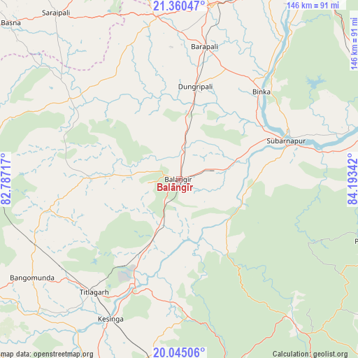
Balāngīr GPS coordinates[2]
20° 42' 15.084" North, 83° 29' 25.044" East
| Map corner | latitude | longitude |
|---|---|---|
| Upper-left | 21.36047°, | 82.78717° |
| Center: | 20.70419°, | 83.49029° |
| Lower-right: | 20.04506°, | 84.19342° |
| Map W x H: | 146.3×146.3 km | = 90.9×90.9mi |
| max Lat: | 34.9274° ⇑63.1% North |
| Balāngīr: | 20.70419° |
| min Lat: | ⇓36.9% South 8.09008° |
| min Long | Balāngīr | max Long |
| 68.82655° | 83.49029° | 96.81° |
| W 80.7%⇐ | ⇒19.3% E |
Elevation
Elevation of Balāngīr is 187 m = 614 ft, and this is 108.6 m = 356 ft below average elevation for this country.
| Max E: |
3681 m = 12077 ft | 52.5% |
| Avg. | 295.6 m = 970 ft | |
| Balāngīr | 187 m = 614 ft | |
Min E: |
1 m = 3 ft | 47.5% |
See also: Balāngīr elevation on elevation.city.
Geographical zone
Balāngīr is located in North Torrid zone (between Equator and Tropic of Cancer). Distance of this Northern Tropic circle is 303.8 km =188.8 mi to North.| Distance of | km | miles | from Balāngīr |
|---|---|---|---|
| North Pole | 7705 | 4787.7 | to North |
| Arctic Circle | 5099.1 | 3168.4 | to North |
| Tropic Cancer | 303.8 | 188.8 | to North |
| Equator | 2302.1 | 1430.5 | to South |


Nearby cities:
15 places around Balāngīr: (largest is in red/bold)
• Bargarh
71.2 km =44.2 mi,  10°
10°
• Barpāli
55 km =34.2 mi, 10°
• Basna
94 km =58.4 mi,  312°
312°
• Baud
88.2 km =54.8 mi,  80°
80°
• Binka
49 km =30.4 mi,  43°
43°
• Kantābānji
64.9 km =40.3 mi,  246°
246°
• Kesinga
64 km =39.8 mi,  206°
206°
• Kharhiāl
89 km =55.3 mi,  238°
238°
• Padampur
55.2 km =34.3 mi, 306°
• Patnāgarh
37.2 km =23.1 mi,  270°
270°
• Phulbāni
81 km =50.3 mi,  107°
107°
• Saraipali
84.5 km =52.5 mi,  323°
323°
• Sonepur
46.6 km =29 mi,  72°
72°
• Tarabha
19.4 km =12.1 mi, 80°
• Titlāgarh
58 km =36 mi,  217°
217°
Sources, notices
• [Note1] Compared only with cities in India existing in our database
• [Src1] Map data: © OpenStreetMap contributors (CC-BY-SA)
• [Src2] Other city data from geonames.org with taken over terms of usage.
• [Src3] Geographical zone / Annual Mean Temperature by Robert A. Rohde @ Wikipedia
