Gawān geodata
Gawān (Uttar Pradesh) is a populated place; located in India in Asia/Kolkata (GMT+5.5) time zone. With population of 8,744 people, there are 3062 cities with bigger population in this country. Compared to other cities in India, 86.4% of cities are located further ↓South; 52.7% of cities are located further ←West and 51.9% of cities have higher elevation than Gawān. Note1


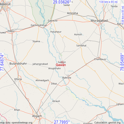
Gawān GPS coordinates[2]
28° 25' 10.884" North, 78° 21' 6.696" East
| Map corner | latitude | longitude |
|---|---|---|
| Upper-left | 29.03626°, | 77.64874° |
| Center: | 28.41969°, | 78.35186° |
| Lower-right: | 27.7995°, | 79.05499° |
| Map W x H: | 137.5×137.5 km | = 85.4×85.4mi |
| max Lat: | 34.9274° ⇑13.6% North |
| Gawān: | 28.41969° |
| min Lat: | ⇓86.4% South 8.09008° |
| min Long | Gawān | max Long |
| 68.82655° | 78.35186° | 96.81° |
| W 52.7%⇐ | ⇒47.3% E |
Elevation
Elevation of Gawān is 191 m = 627 ft, and this is 104.6 m = 343 ft below average elevation for this country.
| Max E: |
3681 m = 12077 ft | 51.9% |
| Avg. | 295.6 m = 970 ft | |
| Gawān | 191 m = 627 ft | |
Min E: |
1 m = 3 ft | 48.1% |
See also: India elevation on elevation.city.
Geographical zone
Gawān is located in North temperate zone (between Tropic of Cancer and the Arctic Circle). Distance of this Northern Tropic circle is 554.1 km =344.3 mi to South.| Distance of | km | miles | from Gawān |
|---|---|---|---|
| North Pole | 6847.1 | 4254.6 | to North |
| Arctic Circle | 4241.2 | 2635.4 | to North |
| Tropic Cancer | 554.1 | 344.3 | to South |
| Equator | 3160 | 1963.5 | to South |


Nearby cities:
15 places around Gawān: (largest is in red/bold)
• Anūpshahr
10.6 km =6.6 mi,  229°
229°
• Babrāla
18.1 km =11.2 mi,  163°
163°
• Bahjoi
27 km =16.8 mi,  95°
95°
• Dibai
25.1 km =15.6 mi,  200°
200°
• Gunnaur
21.8 km =13.5 mi, 156°
• Hasanpur
34.3 km =21.3 mi,  348°
348°
• Islāmnagar
37.9 km =23.5 mi,  105°
105°
• Jahāngīrābād
24.1 km =15 mi,  266°
266°
• Khānpur
30.8 km =19.1 mi,  294°
294°
• Narauli
36.2 km =22.5 mi,  78°
78°
• Naraura
24.5 km =15.2 mi,  171°
171°
• Pahāsu
39.4 km =24.5 mi, 225°
• Sambhal
28.1 km =17.5 mi,  49°
49°
• Shikārpūr
36.5 km =22.7 mi,  244°
244°
• Sirsi
37.5 km =23.3 mi, 49°
Sources, notices
• [Note1] Compared only with cities in India existing in our database
• [Src1] Map data: © OpenStreetMap contributors (CC-BY-SA)
• [Src2] Other city data from geonames.org with taken over terms of usage.
• [Src3] Geographical zone / Annual Mean Temperature by Robert A. Rohde @ Wikipedia
