Hasanpur geodata
Hasanpur (Uttar Pradesh) is a populated place; located in India in Asia/Kolkata (GMT+5.5) time zone. With population of 57,481 people, there are 765 cities with bigger population in this country. Compared to other cities in India, 87.9% of cities are located further ↓South; 52.2% of cities are located further ←West and 51.6% of cities have lower elevation than Hasanpur. Note1


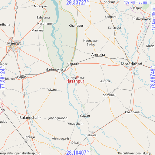
Hasanpur GPS coordinates[2]
28° 43' 20.964" North, 78° 17' 3.696" East
| Map corner | latitude | longitude |
|---|---|---|
| Upper-left | 29.33727°, | 77.58124° |
| Center: | 28.72249°, | 78.28436° |
| Lower-right: | 28.10407°, | 78.98749° |
| Map W x H: | 137.1×137.1 km | = 85.2×85.2mi |
| max Lat: | 34.9274° ⇑12.1% North |
| Hasanpur: | 28.72249° |
| min Lat: | ⇓87.9% South 8.09008° |
| min Long | Hasanpur | max Long |
| 68.82655° | 78.28436° | 96.81° |
| W 52.2%⇐ | ⇒47.8% E |
Elevation
Elevation of Hasanpur is 211 m = 692 ft, and this is 84.6 m = 278 ft below average elevation for this country.
| Max E: |
3681 m = 12077 ft | 48.4% |
| Avg. | 295.6 m = 970 ft | |
| Hasanpur | 211 m = 692 ft | |
Min E: |
1 m = 3 ft | 51.6% |
See also: Hasanpur elevation on elevation.city.
Geographical zone
Hasanpur is located in North temperate zone (between Tropic of Cancer and the Arctic Circle). Distance of this Northern Tropic circle is 587.7 km =365.2 mi to South.| Distance of | km | miles | from Hasanpur |
|---|---|---|---|
| North Pole | 6813.4 | 4233.6 | to North |
| Arctic Circle | 4207.5 | 2614.4 | to North |
| Tropic Cancer | 587.7 | 365.2 | to South |
| Equator | 3193.6 | 1984.4 | to South |


Nearby cities:
15 places around Hasanpur: (largest is in red/bold)
• Amroha
27 km =16.8 mi,  41°
41°
• Anūpshahr
40.6 km =25.2 mi,  182°
182°
• Babugarh
42.7 km =26.5 mi,  270°
270°
• Bachhraon
23.2 km =14.4 mi,  347°
347°
• Dhanaura
26.5 km =16.5 mi, 354°
• Gajraula
14.4 km =8.9 mi,  342°
342°
• Garhmuktesar
19.2 km =11.9 mi,  292°
292°
• Gawān
34.3 km =21.3 mi,  168°
168°
• Jahāngīrābād
39.3 km =24.4 mi,  206°
206°
• Khānpur
29.9 km =18.6 mi,  225°
225°
• Kithor
37.3 km =23.2 mi,  295°
295°
• Parīchhatgarh
44.4 km =27.6 mi,  309°
309°
• Saidpur
38.7 km =24 mi,  251°
251°
• Sambhal
31.8 km =19.8 mi,  118°
118°
• Sirsi
36.2 km =22.5 mi,  104°
104°
Sources, notices
• [Note1] Compared only with cities in India existing in our database
• [Src1] Map data: © OpenStreetMap contributors (CC-BY-SA)
• [Src2] Other city data from geonames.org with taken over terms of usage.
• [Src3] Geographical zone / Annual Mean Temperature by Robert A. Rohde @ Wikipedia
