Gajraula geodata
Gajraula (Uttar Pradesh) is a populated place; located in India in Asia/Kolkata (GMT+5.5) time zone. With population of 50,380 people, there are 883 cities with bigger population in this country. Compared to other cities in India, 88.5% of cities are located further ↓South; 51.7% of cities are located further ←West and 51.9% of cities have lower elevation than Gajraula. Note1


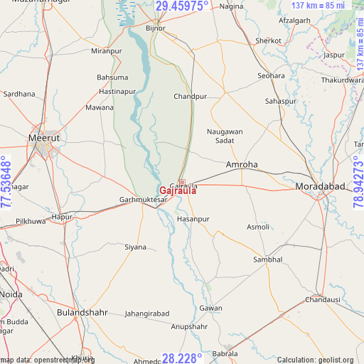
Gajraula GPS coordinates[2]
28° 50' 44.52" North, 78° 14' 22.56" East
| Map corner | latitude | longitude |
|---|---|---|
| Upper-left | 29.45975°, | 77.53648° |
| Center: | 28.8457°, | 78.2396° |
| Lower-right: | 28.228°, | 78.94273° |
| Map W x H: | 137×137 km | = 85.1×85.1mi |
| max Lat: | 34.9274° ⇑11.5% North |
| Gajraula: | 28.8457° |
| min Lat: | ⇓88.5% South 8.09008° |
| min Long | Gajraula | max Long |
| 68.82655° | 78.2396° | 96.81° |
| W 51.7%⇐ | ⇒48.3% E |
Elevation
Elevation of Gajraula is 213 m = 699 ft, and this is 82.6 m = 271 ft below average elevation for this country.
| Max E: |
3681 m = 12077 ft | 48.1% |
| Avg. | 295.6 m = 970 ft | |
| Gajraula | 213 m = 699 ft | |
Min E: |
1 m = 3 ft | 51.9% |
See also: Gajraula elevation on elevation.city.
Geographical zone
Gajraula is located in North temperate zone (between Tropic of Cancer and the Arctic Circle). Distance of this Northern Tropic circle is 601.4 km =373.7 mi to South.| Distance of | km | miles | from Gajraula |
|---|---|---|---|
| North Pole | 6799.7 | 4225.1 | to North |
| Arctic Circle | 4193.8 | 2605.9 | to North |
| Tropic Cancer | 601.4 | 373.7 | to South |
| Equator | 3207.3 | 1992.9 | to South |


Nearby cities:
15 places around Gajraula: (largest is in red/bold)
• Amroha
23.3 km =14.5 mi,  74°
74°
• Babugarh
40.6 km =25.2 mi,  250°
250°
• Bachhraon
9 km =5.6 mi,  356°
356°
• Chāndpur
32.3 km =20.1 mi,  5°
5°
• Dhanaura
12.7 km =7.9 mi, 7°
• Garhmuktesar
14.9 km =9.3 mi,  244°
244°
• Hasanpur
14.4 km =8.9 mi,  162°
162°
• Hastināpur
41.6 km =25.8 mi,  327°
327°
• Khānpur
38.6 km =24 mi,  206°
206°
• Kithor
29.4 km =18.3 mi,  274°
274°
• Mawāna
42.1 km =26.2 mi,  312°
312°
• Nūrpur
37.6 km =23.4 mi,  25°
25°
• Parīchhatgarh
33.2 km =20.6 mi,  296°
296°
• Saidpur
41.5 km =25.8 mi,  230°
230°
• Tājpur
42.5 km =26.4 mi, 34°
Sources, notices
• [Note1] Compared only with cities in India existing in our database
• [Src1] Map data: © OpenStreetMap contributors (CC-BY-SA)
• [Src2] Other city data from geonames.org with taken over terms of usage.
• [Src3] Geographical zone / Annual Mean Temperature by Robert A. Rohde @ Wikipedia
