Leteri geodata
Leteri (Madhya Pradesh) is a populated place; located in India in Asia/Kolkata (GMT+5.5) time zone. With population of 15,519 people, there are 2413 cities with bigger population in this country. Compared to other cities in India, 58.5% of cities are located further ↓South; 58.3% of cities are located further →East and 84.1% of cities have lower elevation than Leteri. Note1


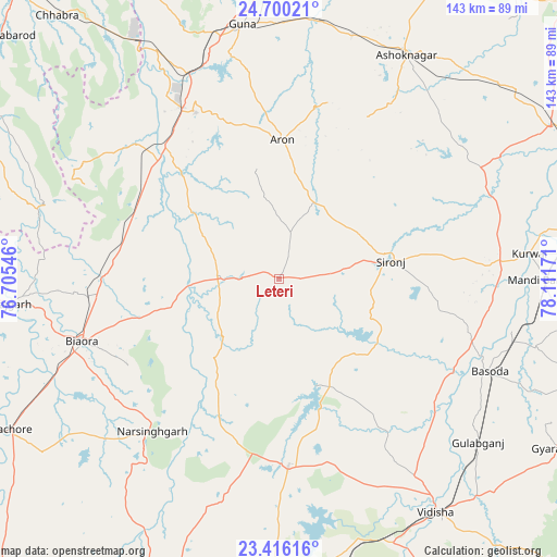
Leteri GPS coordinates[2]
24° 3' 35.244" North, 77° 24' 30.888" East
| Map corner | latitude | longitude |
|---|---|---|
| Upper-left | 24.70021°, | 76.70546° |
| Center: | 24.05979°, | 77.40858° |
| Lower-right: | 23.41616°, | 78.11171° |
| Map W x H: | 142.8×142.8 km | = 88.7×88.7mi |
| max Lat: | 34.9274° ⇑41.5% North |
| Leteri: | 24.05979° |
| min Lat: | ⇓58.5% South 8.09008° |
| min Long | Leteri | max Long |
| 68.82655° | 77.40858° | 96.81° |
| W 41.7%⇐ | ⇒58.3% E |
Elevation
Elevation of Leteri is 534 m = 1752 ft, and this is 238.4 m = 782 ft above average elevation for this country.
| Max E: |
3681 m = 12077 ft | 15.9% |
| Leteri | 534 m 1752 ft | |
| Avg. | 295.6 m = 970 ft | |
Min E: |
1 m = 3 ft | 84.1% |
See also: India elevation on elevation.city.
Geographical zone
Leteri is located in North temperate zone (between Tropic of Cancer and the Arctic Circle). Distance of this Northern Tropic circle is 69.3 km =43.1 mi to South.| Distance of | km | miles | from Leteri |
|---|---|---|---|
| North Pole | 7331.9 | 4555.8 | to North |
| Arctic Circle | 4726 | 2936.6 | to North |
| Tropic Cancer | 69.3 | 43.1 | to South |
| Equator | 2675.2 | 1662.3 | to South |


Nearby cities:
15 places around Leteri: (largest is in red/bold)
• Ashoknagar
66 km =41 mi,  29°
29°
• Berasia
47.7 km =29.6 mi,  176°
176°
• Biaora
52.9 km =32.9 mi,  252°
252°
• Bāsoda
58.4 km =36.3 mi,  113°
113°
• Chandpura
25.6 km =15.9 mi,  206°
206°
• Garha Brahman
21.9 km =13.6 mi,  193°
193°
• Khata Khedi
24.1 km =15 mi, 209°
• Korwai
64.4 km =40 mi,  84°
84°
• Kumbhrāj
50.5 km =31.4 mi,  313°
313°
• Manohar Thāna
64.7 km =40.2 mi,  288°
288°
• Narsinghgarh
50.6 km =31.4 mi,  219°
219°
• Patalpani
24.9 km =15.5 mi, 192°
• Rāghogarh
47.7 km =29.6 mi,  333°
333°
• Sironj
29 km =18 mi, 80°
• Āron
35.7 km =22.2 mi,  1°
1°
Sources, notices
• [Note1] Compared only with cities in India existing in our database
• [Src1] Map data: © OpenStreetMap contributors (CC-BY-SA)
• [Src2] Other city data from geonames.org with taken over terms of usage.
• [Src3] Geographical zone / Annual Mean Temperature by Robert A. Rohde @ Wikipedia
