Āron geodata
Āron (Madhya Pradesh) is a populated place; located in India in Asia/Kolkata (GMT+5.5) time zone. With population of 24,274 people, there are 1752 cities with bigger population in this country. Compared to other cities in India, 59.9% of cities are located further ↓South; 58.2% of cities are located further →East and 83.9% of cities have lower elevation than Āron. Note1


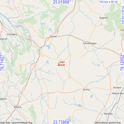
Āron GPS coordinates[2]
24° 22' 51.924" North, 77° 25' 2.604" East
| Map corner | latitude | longitude |
|---|---|---|
| Upper-left | 25.01988°, | 76.71427° |
| Center: | 24.38109°, | 77.41739° |
| Lower-right: | 23.73906°, | 78.12052° |
| Map W x H: | 142.4×142.4 km | = 88.5×88.5mi |
| max Lat: | 34.9274° ⇑40.1% North |
| Āron: | 24.38109° |
| min Lat: | ⇓59.9% South 8.09008° |
| min Long | Āron | max Long |
| 68.82655° | 77.41739° | 96.81° |
| W 41.8%⇐ | ⇒58.2% E |
Elevation
Elevation of Āron is 524 m = 1719 ft, and this is 228.4 m = 749 ft above average elevation for this country.
| Max E: |
3681 m = 12077 ft | 16.1% |
| Āron | 524 m 1719 ft | |
| Avg. | 295.6 m = 970 ft | |
Min E: |
1 m = 3 ft | 83.9% |
See also: India elevation on elevation.city.
Geographical zone
Āron is located in North temperate zone (between Tropic of Cancer and the Arctic Circle). Distance of this Northern Tropic circle is 105 km =65.2 mi to South.| Distance of | km | miles | from Āron |
|---|---|---|---|
| North Pole | 7296.1 | 4533.6 | to North |
| Arctic Circle | 4690.3 | 2914.4 | to North |
| Tropic Cancer | 105 | 65.2 | to South |
| Equator | 2710.9 | 1684.5 | to South |


Nearby cities:
15 places around Āron: (largest is in red/bold)
• Ashoknagar
38.4 km =23.9 mi,  55°
55°
• Badarwās
67.7 km =42.1 mi,  12°
12°
• Bijrauni
65.5 km =40.7 mi,  20°
20°
• Chandpura
59.9 km =37.2 mi,  191°
191°
• Chhabra
66 km =41 mi,  298°
298°
• Garha Brahman
57.3 km =35.6 mi, 186°
• Guna
31.4 km =19.5 mi,  340°
340°
• Khata Khedi
58.1 km =36.1 mi, 192°
• Kumbhrāj
37.4 km =23.2 mi,  268°
268°
• Leteri
35.7 km =22.2 mi,  181°
181°
• Manohar Thāna
64.3 km =40 mi,  255°
255°
• Mungaoli
68.8 km =42.8 mi,  87°
87°
• Patalpani
60.4 km =37.5 mi, 186°
• Rāghogarh
23.3 km =14.5 mi,  287°
287°
• Sironj
41.5 km =25.8 mi,  138°
138°
Sources, notices
• [Note1] Compared only with cities in India existing in our database
• [Src1] Map data: © OpenStreetMap contributors (CC-BY-SA)
• [Src2] Other city data from geonames.org with taken over terms of usage.
• [Src3] Geographical zone / Annual Mean Temperature by Robert A. Rohde @ Wikipedia
