Reoti geodata
Reoti (Uttar Pradesh) is a populated place; located in India in Asia/Kolkata (GMT+5.5) time zone. With population of 23,819 people, there are 1781 cities with bigger population in this country. Compared to other cities in India, 69.3% of cities are located further ↓South; 82.8% of cities are located further ←West and 75.9% of cities have higher elevation than Reoti. Note1


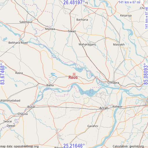
Reoti GPS coordinates[2]
25° 51' 3.276" North, 84° 22' 40.08" East
| Map corner | latitude | longitude |
|---|---|---|
| Upper-left | 26.48197°, | 83.67468° |
| Center: | 25.85091°, | 84.3778° |
| Lower-right: | 25.21646°, | 85.08093° |
| Map W x H: | 140.7×140.7 km | = 87.4×87.4mi |
| max Lat: | 34.9274° ⇑30.7% North |
| Reoti: | 25.85091° |
| min Lat: | ⇓69.3% South 8.09008° |
| min Long | Reoti | max Long |
| 68.82655° | 84.3778° | 96.81° |
| W 82.8%⇐ | ⇒17.2% E |
Elevation
Elevation of Reoti is 64 m = 210 ft, and this is 231.6 m = 760 ft below average elevation for this country.
| Max E: |
3681 m = 12077 ft | 75.9% |
| Avg. | 295.6 m = 970 ft | |
| Reoti | 64 m = 210 ft | |
Min E: |
1 m = 3 ft | 24.1% |
See also: India elevation on elevation.city.
Geographical zone
Reoti is located in North temperate zone (between Tropic of Cancer and the Arctic Circle). Distance of this Northern Tropic circle is 268.4 km =166.8 mi to South.| Distance of | km | miles | from Reoti |
|---|---|---|---|
| North Pole | 7132.7 | 4432.1 | to North |
| Arctic Circle | 4526.8 | 2812.8 | to North |
| Tropic Cancer | 268.4 | 166.8 | to South |
| Equator | 2874.4 | 1786.1 | to South |


Nearby cities:
15 places around Reoti: (largest is in red/bold)
• Arrah
43.5 km =27 mi,  138°
138°
• Buxar
50.2 km =31.2 mi,  232°
232°
• Bānsdīh
16.4 km =10.2 mi,  282°
282°
• Chāpra
37.8 km =23.5 mi,  101°
101°
• Dumraon
40.2 km =25 mi,  214°
214°
• Jagdīspur
42.8 km =26.6 mi,  174°
174°
• Koelwār
51.7 km =32.1 mi,  125°
125°
• Mahārājgani
31.5 km =19.6 mi,  23°
23°
• Mairwa
47.5 km =29.5 mi,  333°
333°
• Maniar
25.4 km =15.8 mi,  306°
306°
• Marhaura
50.9 km =31.6 mi,  74°
74°
• Revelganj
26.7 km =16.6 mi, 104°
• Shāhpur
27.7 km =17.2 mi, 174°
• Sikandarpur
38.9 km =24.2 mi,  303°
303°
• Siwān
41.2 km =25.6 mi,  356°
356°
Sources, notices
• [Note1] Compared only with cities in India existing in our database
• [Src1] Map data: © OpenStreetMap contributors (CC-BY-SA)
• [Src2] Other city data from geonames.org with taken over terms of usage.
• [Src3] Geographical zone / Annual Mean Temperature by Robert A. Rohde @ Wikipedia
