Mahārājgani geodata
Mahārājgani (Bihar) is a populated place; located in India in Asia/Kolkata (GMT+5.5) time zone. With population of 22,430 people, there are 1882 cities with bigger population in this country. Compared to other cities in India, 71.2% of cities are located further ↓South; 83.1% of cities are located further ←West and 75.2% of cities have higher elevation than Mahārājgani. Note1


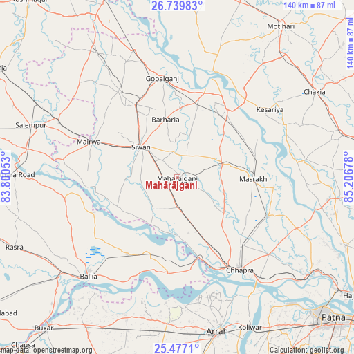
Mahārājgani GPS coordinates[2]
26° 6' 36.612" North, 84° 30' 13.14" East
| Map corner | latitude | longitude |
|---|---|---|
| Upper-left | 26.73983°, | 83.80053° |
| Center: | 26.11017°, | 84.50365° |
| Lower-right: | 25.4771°, | 85.20678° |
| Map W x H: | 140.4×140.4 km | = 87.2×87.2mi |
| max Lat: | 34.9274° ⇑28.8% North |
| Mahārājgani: | 26.11017° |
| min Lat: | ⇓71.2% South 8.09008° |
| min Long | Mahārājgani | max Long |
| 68.82655° | 84.50365° | 96.81° |
| W 83.1%⇐ | ⇒16.9% E |
Elevation
Elevation of Mahārājgani is 67 m = 220 ft, and this is 228.6 m = 750 ft below average elevation for this country.
| Max E: |
3681 m = 12077 ft | 75.2% |
| Avg. | 295.6 m = 970 ft | |
| Mahārājgani | 67 m = 220 ft | |
Min E: |
1 m = 3 ft | 24.8% |
See also: India elevation on elevation.city.
Geographical zone
Mahārājgani is located in North temperate zone (between Tropic of Cancer and the Arctic Circle). Distance of this Northern Tropic circle is 297.3 km =184.7 mi to South.| Distance of | km | miles | from Mahārājgani |
|---|---|---|---|
| North Pole | 7103.9 | 4414.2 | to North |
| Arctic Circle | 4498 | 2794.9 | to North |
| Tropic Cancer | 297.3 | 184.7 | to South |
| Equator | 2903.2 | 1804 | to South |


Nearby cities:
15 places around Mahārājgani: (largest is in red/bold)
• Barauli
31.2 km =19.4 mi,  15°
15°
• Bilthra
61.1 km =38 mi,  271°
271°
• Bānsdīh
38 km =23.6 mi,  228°
228°
• Chāpra
44 km =27.3 mi,  146°
146°
• Gopālganj
40.2 km =25 mi,  350°
350°
• Lar
54.4 km =33.8 mi,  281°
281°
• Mairwa
36.6 km =22.7 mi,  291°
291°
• Maner
63.5 km =39.5 mi,  144°
144°
• Maniar
35.9 km =22.3 mi,  247°
247°
• Marhaura
39.4 km =24.5 mi,  112°
112°
• Reoti
31.5 km =19.6 mi,  203°
203°
• Revelganj
38 km =23.6 mi,  159°
159°
• Shāhpur
57.3 km =35.6 mi,  190°
190°
• Sikandarpur
45.6 km =28.3 mi,  260°
260°
• Siwān
19.2 km =11.9 mi,  309°
309°
Sources, notices
• [Note1] Compared only with cities in India existing in our database
• [Src1] Map data: © OpenStreetMap contributors (CC-BY-SA)
• [Src2] Other city data from geonames.org with taken over terms of usage.
• [Src3] Geographical zone / Annual Mean Temperature by Robert A. Rohde @ Wikipedia
