Lingsugūr geodata
Lingsugūr (Karnataka) is a populated place; located in India in Asia/Kolkata (GMT+5.5) time zone. With population of 29,783 people, there are 1456 cities with bigger population in this country. Compared to other cities in India, 77.6% of cities are located further ↑North; 68.1% of cities are located further →East and 83.1% of cities have lower elevation than Lingsugūr. Note1


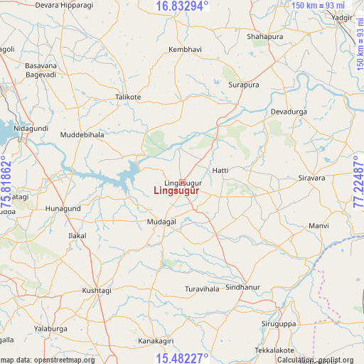
Lingsugūr GPS coordinates[2]
16° 9' 31.536" North, 76° 31' 18.264" East
| Map corner | latitude | longitude |
|---|---|---|
| Upper-left | 16.83294°, | 75.81862° |
| Center: | 16.15876°, | 76.52174° |
| Lower-right: | 15.48227°, | 77.22487° |
| Map W x H: | 150.2×150.2 km | = 93.3×93.3mi |
| max Lat: | 34.9274° ⇑77.6% North |
| Lingsugūr: | 16.15876° |
| min Lat: | ⇓22.4% South 8.09008° |
| min Long | Lingsugūr | max Long |
| 68.82655° | 76.52174° | 96.81° |
| W 31.9%⇐ | ⇒68.1% E |
Elevation
Elevation of Lingsugūr is 509 m = 1670 ft, and this is 213.4 m = 700 ft above average elevation for this country.
| Max E: |
3681 m = 12077 ft | 16.9% |
| Lingsugūr | 509 m 1670 ft | |
| Avg. | 295.6 m = 970 ft | |
Min E: |
1 m = 3 ft | 83.1% |
See also: India elevation on elevation.city.
Geographical zone
Lingsugūr is located in North Torrid zone (between Equator and Tropic of Cancer). Distance of this Northern Tropic circle is 809.2 km =502.8 mi to North.| Distance of | km | miles | from Lingsugūr |
|---|---|---|---|
| North Pole | 8210.4 | 5101.7 | to North |
| Arctic Circle | 5604.5 | 3482.5 | to North |
| Tropic Cancer | 809.2 | 502.8 | to North |
| Equator | 1796.7 | 1116.4 | to South |


Nearby cities:
15 places around Lingsugūr: (largest is in red/bold)
• Basavana Bāgevādi
74.5 km =46.3 mi,  308°
308°
• Gajendragarh
75.4 km =46.9 mi,  231°
231°
• Guledagudda
79.1 km =49.2 mi,  261°
261°
• Hungund
50.6 km =31.4 mi, 257°
• Ilkal
48.9 km =30.4 mi,  243°
243°
• Kushtagi
57 km =35.4 mi,  218°
218°
• Muddebihāl
46.1 km =28.6 mi,  295°
295°
• Mudgal
18.4 km =11.4 mi,  207°
207°
• Mānvi
59.5 km =37 mi,  108°
108°
• Shorāpur
47.5 km =29.5 mi,  31°
31°
• Shāhpur
68.8 km =42.8 mi, 29°
• Sindhnūr
50 km =31.1 mi,  149°
149°
• Siruguppa
70.9 km =44.1 mi, 146°
• Tekkalakote
79.1 km =49.2 mi, 151°
• Tālīkota
41.6 km =25.8 mi,  327°
327°
Sources, notices
• [Note1] Compared only with cities in India existing in our database
• [Src1] Map data: © OpenStreetMap contributors (CC-BY-SA)
• [Src2] Other city data from geonames.org with taken over terms of usage.
• [Src3] Geographical zone / Annual Mean Temperature by Robert A. Rohde @ Wikipedia
