Muddebihāl geodata
Muddebihāl (Karnataka) is a populated place; located in India in Asia/Kolkata (GMT+5.5) time zone. With population of 31,895 people, there are 1362 cities with bigger population in this country. Compared to other cities in India, 77.1% of cities are located further ↑North; 72.3% of cities are located further →East and 87.5% of cities have lower elevation than Muddebihāl. Note1


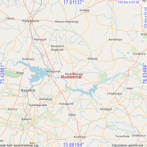
Muddebihāl GPS coordinates[2]
16° 20' 16.152" North, 76° 7' 54.228" East
| Map corner | latitude | longitude |
|---|---|---|
| Upper-left | 17.01137°, | 75.42861° |
| Center: | 16.33782°, | 76.13173° |
| Lower-right: | 15.66194°, | 76.83486° |
| Map W x H: | 150×150 km | = 93.2×93.2mi |
| max Lat: | 34.9274° ⇑77.1% North |
| Muddebihāl: | 16.33782° |
| min Lat: | ⇓22.9% South 8.09008° |
| min Long | Muddebihāl | max Long |
| 68.82655° | 76.13173° | 96.81° |
| W 27.7%⇐ | ⇒72.3% E |
Elevation
Elevation of Muddebihāl is 586 m = 1923 ft, and this is 290.4 m = 953 ft above average elevation for this country.
| Max E: |
3681 m = 12077 ft | 12.5% |
| Muddebihāl | 586 m 1923 ft | |
| Avg. | 295.6 m = 970 ft | |
Min E: |
1 m = 3 ft | 87.5% |
See also: India elevation on elevation.city.
Geographical zone
Muddebihāl is located in North Torrid zone (between Equator and Tropic of Cancer). Distance of this Northern Tropic circle is 789.3 km =490.4 mi to North.| Distance of | km | miles | from Muddebihāl |
|---|---|---|---|
| North Pole | 8190.5 | 5089.3 | to North |
| Arctic Circle | 5584.6 | 3470.1 | to North |
| Tropic Cancer | 789.3 | 490.4 | to North |
| Equator | 1816.6 | 1128.8 | to South |


Nearby cities:
15 places around Muddebihāl: (largest is in red/bold)
• Bagalkot
49.4 km =30.7 mi,  250°
250°
• Basavana Bāgevādi
31.2 km =19.4 mi,  326°
326°
• Bijapur
70 km =43.5 mi,  320°
320°
• Bilgi
54.8 km =34.1 mi,  271°
271°
• Bādāmi
67.6 km =42 mi,  225°
225°
• Gajendragarh
69.1 km =42.9 mi,  194°
194°
• Guledagudda
48.5 km =30.1 mi, 228°
• Hungund
31.6 km =19.6 mi, 194°
• Ilkal
42.1 km =26.2 mi,  182°
182°
• Kushtagi
65 km =40.4 mi,  174°
174°
• Lingsugūr
46.1 km =28.6 mi,  115°
115°
• Mudgal
49.1 km =30.5 mi,  137°
137°
• Shorāpur
69.8 km =43.4 mi,  73°
73°
• Sindgi
65.5 km =40.7 mi,  9°
9°
• Tālīkota
24.3 km =15.1 mi,  51°
51°
Sources, notices
• [Note1] Compared only with cities in India existing in our database
• [Src1] Map data: © OpenStreetMap contributors (CC-BY-SA)
• [Src2] Other city data from geonames.org with taken over terms of usage.
• [Src3] Geographical zone / Annual Mean Temperature by Robert A. Rohde @ Wikipedia
