Phaltan geodata
Phaltan (Maharashtra) is a populated place; located in India in Asia/Kolkata (GMT+5.5) time zone. With population of 53,202 people, there are 837 cities with bigger population in this country. Compared to other cities in India, 71.8% of cities are located further ↑North; 87.4% of cities are located further →East and 85.9% of cities have lower elevation than Phaltan. Note1


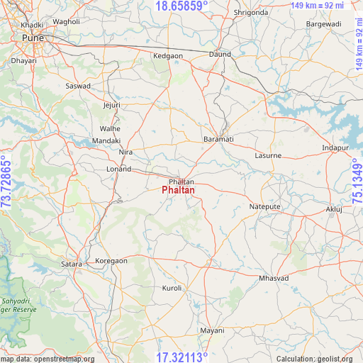
Phaltan GPS coordinates[2]
17° 59' 28.068" North, 74° 25' 54.372" East
| Map corner | latitude | longitude |
|---|---|---|
| Upper-left | 18.65859°, | 73.72865° |
| Center: | 17.99113°, | 74.43177° |
| Lower-right: | 17.32113°, | 75.1349° |
| Map W x H: | 148.7×148.7 km | = 92.4×92.4mi |
| max Lat: | 34.9274° ⇑71.8% North |
| Phaltan: | 17.99113° |
| min Lat: | ⇓28.2% South 8.09008° |
| min Long | Phaltan | max Long |
| 68.82655° | 74.43177° | 96.81° |
| W 12.6%⇐ | ⇒87.4% E |
Elevation
Elevation of Phaltan is 560 m = 1837 ft, and this is 264.4 m = 867 ft above average elevation for this country.
| Max E: |
3681 m = 12077 ft | 14.1% |
| Phaltan | 560 m 1837 ft | |
| Avg. | 295.6 m = 970 ft | |
Min E: |
1 m = 3 ft | 85.9% |
See also: Phaltan elevation on elevation.city.
Geographical zone
Phaltan is located in North Torrid zone (between Equator and Tropic of Cancer). Distance of this Northern Tropic circle is 605.5 km =376.2 mi to North.| Distance of | km | miles | from Phaltan |
|---|---|---|---|
| North Pole | 8006.6 | 4975.1 | to North |
| Arctic Circle | 5400.7 | 3355.8 | to North |
| Tropic Cancer | 605.5 | 376.2 | to North |
| Equator | 2000.4 | 1243 | to South |


Nearby cities:
15 places around Phaltan: (largest is in red/bold)
• Bhigvan
49.4 km =30.7 mi,  45°
45°
• Bhor
64.6 km =40.1 mi,  285°
285°
• Bārāmati
23.6 km =14.7 mi,  40°
40°
• Daund
55.1 km =34.2 mi,  16°
16°
• Jejūri
42.8 km =26.6 mi,  317°
317°
• Kalas
42.9 km =26.7 mi,  62°
62°
• Khed
72.9 km =45.3 mi,  301°
301°
• Mhāsvād
54.8 km =34.1 mi,  136°
136°
• Pānchgani
67.1 km =41.7 mi,  263°
263°
• Rahimatpur
50.7 km =31.5 mi,  208°
208°
• Satara
57.5 km =35.7 mi,  233°
233°
• Shirwal
51.1 km =31.8 mi, 290°
• Shrīgonda
74.9 km =46.5 mi, 22°
• Sāsvad
57.7 km =35.9 mi,  312°
312°
• Wai
57.4 km =35.7 mi,  265°
265°
Sources, notices
• [Note1] Compared only with cities in India existing in our database
• [Src1] Map data: © OpenStreetMap contributors (CC-BY-SA)
• [Src2] Other city data from geonames.org with taken over terms of usage.
• [Src3] Geographical zone / Annual Mean Temperature by Robert A. Rohde @ Wikipedia
