Taloda geodata
Taloda (Maharashtra) is a populated place; located in India in Asia/Kolkata (GMT+5.5) time zone. With population of 26,293 people, there are 1621 cities with bigger population in this country. Compared to other cities in India, 58.7% of cities are located further ↑North; 88.3% of cities are located further →East and 64.2% of cities have higher elevation than Taloda. Note1


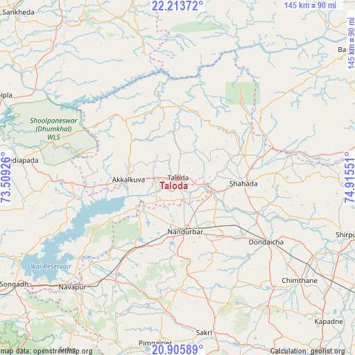
Taloda GPS coordinates[2]
21° 33' 40.608" North, 74° 12' 44.568" East
| Map corner | latitude | longitude |
|---|---|---|
| Upper-left | 22.21372°, | 73.50926° |
| Center: | 21.56128°, | 74.21238° |
| Lower-right: | 20.90589°, | 74.91551° |
| Map W x H: | 145.4×145.4 km | = 90.3×90.3mi |
| max Lat: | 34.9274° ⇑58.7% North |
| Taloda: | 21.56128° |
| min Lat: | ⇓41.3% South 8.09008° |
| min Long | Taloda | max Long |
| 68.82655° | 74.21238° | 96.81° |
| W 11.7%⇐ | ⇒88.3% E |
Elevation
Elevation of Taloda is 126 m = 413 ft, and this is 169.6 m = 556 ft below average elevation for this country.
| Max E: |
3681 m = 12077 ft | 64.2% |
| Avg. | 295.6 m = 970 ft | |
| Taloda | 126 m = 413 ft | |
Min E: |
1 m = 3 ft | 35.8% |
See also: India elevation on elevation.city.
Geographical zone
Taloda is located in North Torrid zone (between Equator and Tropic of Cancer). Distance of this Northern Tropic circle is 208.5 km =129.6 mi to North.| Distance of | km | miles | from Taloda |
|---|---|---|---|
| North Pole | 7609.7 | 4728.4 | to North |
| Arctic Circle | 5003.8 | 3109.2 | to North |
| Tropic Cancer | 208.5 | 129.6 | to North |
| Equator | 2397.4 | 1489.7 | to South |


Nearby cities:
15 places around Taloda: (largest is in red/bold)
• Barwāni
88.2 km =54.8 mi,  53°
53°
• Chhota Udepur
85 km =52.8 mi,  346°
346°
• Dhūlia
93.9 km =58.3 mi,  141°
141°
• Dondaicha
45.3 km =28.1 mi,  125°
125°
• Kawānt
61.4 km =38.2 mi,  344°
344°
• Khetia
40.4 km =25.1 mi,  72°
72°
• Kukshi
91.2 km =56.7 mi,  38°
38°
• Nandurbar
21.8 km =13.5 mi,  172°
172°
• Pānsemāl
51.5 km =32 mi,  77°
77°
• Rajpur
83.9 km =52.1 mi,  10°
10°
• Rājpīpla
81 km =50.3 mi,  294°
294°
• Sendhwa
92.4 km =57.4 mi, 81°
• Shirpur
73.1 km =45.4 mi,  108°
108°
• Shāhāda
26.8 km =16.7 mi,  93°
93°
• Songadh
80.1 km =49.8 mi,  237°
237°
Sources, notices
• [Note1] Compared only with cities in India existing in our database
• [Src1] Map data: © OpenStreetMap contributors (CC-BY-SA)
• [Src2] Other city data from geonames.org with taken over terms of usage.
• [Src3] Geographical zone / Annual Mean Temperature by Robert A. Rohde @ Wikipedia
