Pachmarhi geodata
Pachmarhi (Madhya Pradesh) is a populated place; located in India in Asia/Kolkata (GMT+5.5) time zone. With population of 3,228 people, there are 3406 cities with bigger population in this country. Compared to other cities in India, 53.4% of cities are located further ↑North; 53.4% of cities are located further ←West and 96.4% of cities have lower elevation than Pachmarhi. Note1


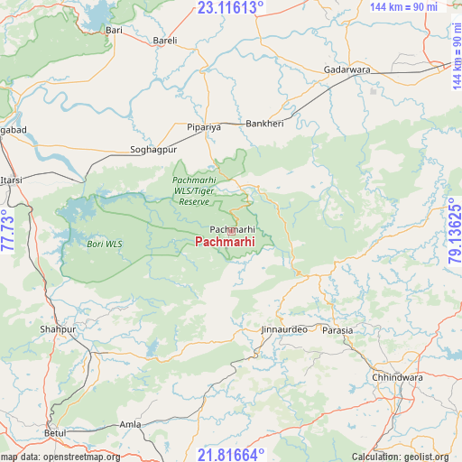
Pachmarhi GPS coordinates[2]
22° 28' 4.476" North, 78° 25' 59.232" East
| Map corner | latitude | longitude |
|---|---|---|
| Upper-left | 23.11613°, | 77.73° |
| Center: | 22.46791°, | 78.43312° |
| Lower-right: | 21.81664°, | 79.13625° |
| Map W x H: | 144.5×144.5 km | = 89.8×89.8mi |
| max Lat: | 34.9274° ⇑53.4% North |
| Pachmarhi: | 22.46791° |
| min Lat: | ⇓46.6% South 8.09008° |
| min Long | Pachmarhi | max Long |
| 68.82655° | 78.43312° | 96.81° |
| W 53.4%⇐ | ⇒46.6% E |
Elevation
Elevation of Pachmarhi is 1061 m = 3481 ft, and this is 765.4 m = 2511 ft above average elevation for this country.
| Max E: |
3681 m = 12077 ft | 3.6% |
| Pachmarhi | 1061 m 3481 ft | |
| Avg. | 295.6 m = 970 ft | |
Min E: |
1 m = 3 ft | 96.4% |
See also: India elevation on elevation.city.
Geographical zone
Pachmarhi is located in North Torrid zone (between Equator and Tropic of Cancer). Distance of this Northern Tropic circle is 107.7 km =66.9 mi to North.| Distance of | km | miles | from Pachmarhi |
|---|---|---|---|
| North Pole | 7508.9 | 4665.8 | to North |
| Arctic Circle | 4903 | 3046.6 | to North |
| Tropic Cancer | 107.7 | 66.9 | to North |
| Equator | 2498.2 | 1552.3 | to South |


Nearby cities:
15 places around Pachmarhi: (largest is in red/bold)
• Amarwāra
78 km =48.5 mi,  104°
104°
• Amla
68.1 km =42.3 mi,  207°
207°
• Bābai
57.4 km =35.7 mi,  297°
297°
• Chhindwāra
69.3 km =43.1 mi,  131°
131°
• Chichli
57.3 km =35.6 mi,  44°
44°
• Gādarwāra
62.2 km =38.6 mi, 35°
• Hoshangābād
78.8 km =49 mi,  293°
293°
• Itārsi
70.8 km =44 mi,  283°
283°
• Jāmai
34.3 km =21.3 mi,  151°
151°
• Multai
79.2 km =49.2 mi,  193°
193°
• Panara
31.6 km =19.6 mi,  157°
157°
• Parāsia
45.5 km =28.3 mi, 132°
• Shāhpur
62 km =38.5 mi,  240°
240°
• Sohāgpur
35.6 km =22.1 mi,  316°
316°
• Udaipura
67.9 km =42.2 mi,  6°
6°
Sources, notices
• [Note1] Compared only with cities in India existing in our database
• [Src1] Map data: © OpenStreetMap contributors (CC-BY-SA)
• [Src2] Other city data from geonames.org with taken over terms of usage.
• [Src3] Geographical zone / Annual Mean Temperature by Robert A. Rohde @ Wikipedia
