Afzalpur geodata
Afzalpur (Karnataka) is a populated place; located in India in Asia/Kolkata (GMT+5.5) time zone. With population of 20,094 people, there are 2035 cities with bigger population in this country. Compared to other cities in India, 74.3% of cities are located further ↑North; 69.7% of cities are located further →East and 77.5% of cities have lower elevation than Afzalpur. Note1


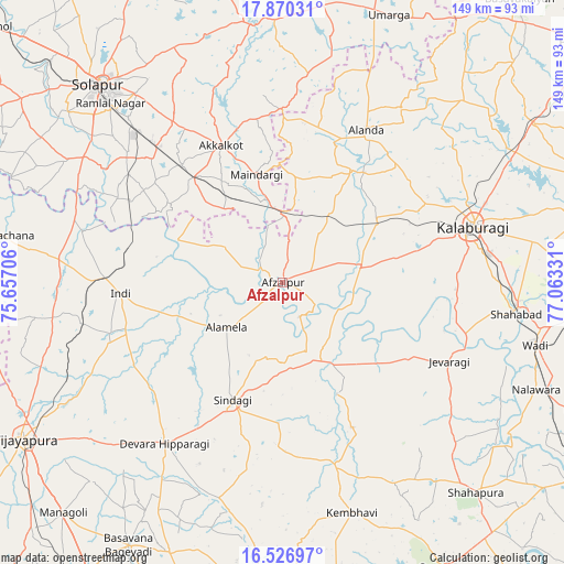
Afzalpur GPS coordinates[2]
17° 11' 59.496" North, 76° 21' 36.648" East
| Map corner | latitude | longitude |
|---|---|---|
| Upper-left | 17.87031°, | 75.65706° |
| Center: | 17.19986°, | 76.36018° |
| Lower-right: | 16.52697°, | 77.06331° |
| Map W x H: | 149.4×149.4 km | = 92.8×92.8mi |
| max Lat: | 34.9274° ⇑74.3% North |
| Afzalpur: | 17.19986° |
| min Lat: | ⇓25.7% South 8.09008° |
| min Long | Afzalpur | max Long |
| 68.82655° | 76.36018° | 96.81° |
| W 30.3%⇐ | ⇒69.7% E |
Elevation
Elevation of Afzalpur is 422 m = 1385 ft, and this is 126.4 m = 415 ft above average elevation for this country.
| Max E: |
3681 m = 12077 ft | 22.5% |
| Afzalpur | 422 m 1385 ft | |
| Avg. | 295.6 m = 970 ft | |
Min E: |
1 m = 3 ft | 77.5% |
See also: India elevation on elevation.city.
Geographical zone
Afzalpur is located in North Torrid zone (between Equator and Tropic of Cancer). Distance of this Northern Tropic circle is 693.5 km =430.9 mi to North.| Distance of | km | miles | from Afzalpur |
|---|---|---|---|
| North Pole | 8094.6 | 5029.7 | to North |
| Arctic Circle | 5488.7 | 3410.5 | to North |
| Tropic Cancer | 693.5 | 430.9 | to North |
| Equator | 1912.4 | 1188.3 | to South |


Nearby cities:
15 places around Afzalpur: (largest is in red/bold)
• Akalkot
39.7 km =24.7 mi,  335°
335°
• Aland
46.2 km =28.7 mi,  28°
28°
• Dudhani
17.6 km =10.9 mi,  2°
2°
• Gulbarga
52.9 km =32.9 mi,  73°
73°
• Indi
43.4 km =27 mi,  266°
266°
• Jevargi
48.5 km =30.1 mi,  115°
115°
• Maindargi
29.5 km =18.3 mi,  346°
346°
• Moram
66.5 km =41.3 mi,  10°
10°
• Naldurg
69.1 km =42.9 mi, 353°
• Shāhpur
75.9 km =47.2 mi,  137°
137°
• Shāhābād
62.5 km =38.8 mi,  97°
97°
• Sindgi
34 km =21.1 mi,  203°
203°
• Solāpur
70.9 km =44.1 mi,  317°
317°
• Umarga
76.3 km =47.4 mi,  21°
21°
• Wādi
69 km =42.9 mi, 103°
Sources, notices
• [Note1] Compared only with cities in India existing in our database
• [Src1] Map data: © OpenStreetMap contributors (CC-BY-SA)
• [Src2] Other city data from geonames.org with taken over terms of usage.
• [Src3] Geographical zone / Annual Mean Temperature by Robert A. Rohde @ Wikipedia
