Gulbarga geodata
Gulbarga (Karnataka) is a populated place; located in India in Asia/Kolkata (GMT+5.5) time zone. With population of 483,615 people, there are 93 cities with bigger population in this country. Compared to other cities in India, 74% of cities are located further ↑North; 64.9% of cities are located further →East and 81.1% of cities have lower elevation than Gulbarga. Note1


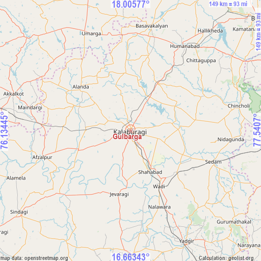
Gulbarga GPS coordinates[2]
17° 20' 8.988" North, 76° 50' 15.252" East
| Map corner | latitude | longitude |
|---|---|---|
| Upper-left | 18.00577°, | 76.13445° |
| Center: | 17.33583°, | 76.83757° |
| Lower-right: | 16.66343°, | 77.5407° |
| Map W x H: | 149.3×149.3 km | = 92.8×92.8mi |
| max Lat: | 34.9274° ⇑74% North |
| Gulbarga: | 17.33583° |
| min Lat: | ⇓26% South 8.09008° |
| min Long | Gulbarga | max Long |
| 68.82655° | 76.83757° | 96.81° |
| W 35.1%⇐ | ⇒64.9% E |
Elevation
Elevation of Gulbarga is 474 m = 1555 ft, and this is 178.4 m = 585 ft above average elevation for this country.
| Max E: |
3681 m = 12077 ft | 18.9% |
| Gulbarga | 474 m 1555 ft | |
| Avg. | 295.6 m = 970 ft | |
Min E: |
1 m = 3 ft | 81.1% |
See also: Gulbarga elevation on elevation.city.
Geographical zone
Gulbarga is located in North Torrid zone (between Equator and Tropic of Cancer). Distance of this Northern Tropic circle is 678.4 km =421.5 mi to North.| Distance of | km | miles | from Gulbarga |
|---|---|---|---|
| North Pole | 8079.5 | 5020.4 | to North |
| Arctic Circle | 5473.6 | 3401.1 | to North |
| Tropic Cancer | 678.4 | 421.5 | to North |
| Equator | 1927.6 | 1197.8 | to South |


Nearby cities:
15 places around Gulbarga: (largest is in red/bold)
• Afzalpur
52.9 km =32.9 mi,  253°
253°
• Aland
38.2 km =23.7 mi,  311°
311°
• Basavakalyān
61.1 km =38 mi,  11°
11°
• Chincholi
63.3 km =39.3 mi,  76°
76°
• Chītāpur
35.1 km =21.8 mi,  132°
132°
• Dudhani
50 km =31.1 mi,  272°
272°
• Homnābād
57.2 km =35.5 mi,  32°
32°
• Jevargi
36.4 km =22.6 mi,  190°
190°
• Kurgunta
57.5 km =35.7 mi,  106°
106°
• Maindargi
59.3 km =36.8 mi,  283°
283°
• Moram
63.6 km =39.5 mi,  322°
322°
• Seram
51.1 km =31.8 mi, 109°
• Shāhābād
25.4 km =15.8 mi,  153°
153°
• Umarga
60.3 km =37.5 mi,  337°
337°
• Wādi
35.5 km =22.1 mi, 152°
Sources, notices
• [Note1] Compared only with cities in India existing in our database
• [Src1] Map data: © OpenStreetMap contributors (CC-BY-SA)
• [Src2] Other city data from geonames.org with taken over terms of usage.
• [Src3] Geographical zone / Annual Mean Temperature by Robert A. Rohde @ Wikipedia
