Aland geodata
Aland (Karnataka) is a populated place; located in India in Asia/Kolkata (GMT+5.5) time zone. With population of 39,064 people, there are 1131 cities with bigger population in this country. Compared to other cities in India, 73% of cities are located further ↑North; 67.6% of cities are located further →East and 82.4% of cities have lower elevation than Aland. Note1


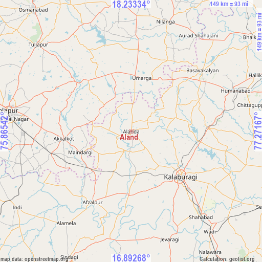
Aland GPS coordinates[2]
17° 33' 51.3" North, 76° 34' 6.744" East
| Map corner | latitude | longitude |
|---|---|---|
| Upper-left | 18.23334°, | 75.86542° |
| Center: | 17.56425°, | 76.56854° |
| Lower-right: | 16.89268°, | 77.27167° |
| Map W x H: | 149.1×149.1 km | = 92.6×92.6mi |
| max Lat: | 34.9274° ⇑73% North |
| Aland: | 17.56425° |
| min Lat: | ⇓27% South 8.09008° |
| min Long | Aland | max Long |
| 68.82655° | 76.56854° | 96.81° |
| W 32.4%⇐ | ⇒67.6% E |
Elevation
Elevation of Aland is 499 m = 1637 ft, and this is 203.4 m = 667 ft above average elevation for this country.
| Max E: |
3681 m = 12077 ft | 17.6% |
| Aland | 499 m 1637 ft | |
| Avg. | 295.6 m = 970 ft | |
Min E: |
1 m = 3 ft | 82.4% |
See also: India elevation on elevation.city.
Geographical zone
Aland is located in North Torrid zone (between Equator and Tropic of Cancer). Distance of this Northern Tropic circle is 653 km =405.8 mi to North.| Distance of | km | miles | from Aland |
|---|---|---|---|
| North Pole | 8054.1 | 5004.6 | to North |
| Arctic Circle | 5448.2 | 3385.4 | to North |
| Tropic Cancer | 653 | 405.8 | to North |
| Equator | 1953 | 1213.5 | to South |


Nearby cities:
15 places around Aland: (largest is in red/bold)
• Afzalpur
46.2 km =28.7 mi,  208°
208°
• Akalkot
38.7 km =24 mi,  263°
263°
• Basavakalyān
53.1 km =33 mi,  49°
49°
• Dudhani
31.4 km =19.5 mi,  222°
222°
• Gulbarga
38.2 km =23.7 mi,  131°
131°
• Homnābād
63.3 km =39.3 mi,  68°
68°
• Jevargi
64.9 km =40.3 mi,  160°
160°
• Maindargi
31.5 km =19.6 mi,  247°
247°
• Moram
27 km =16.8 mi,  337°
337°
• Naldurg
41.4 km =25.7 mi,  312°
312°
• Nilanga
64.5 km =40.1 mi,  17°
17°
• Shāhābād
62.5 km =38.8 mi,  140°
140°
• Solāpur
70.8 km =44 mi,  279°
279°
• Tuljāpur
72.2 km =44.9 mi, 313°
• Umarga
31 km =19.3 mi,  10°
10°
Sources, notices
• [Note1] Compared only with cities in India existing in our database
• [Src1] Map data: © OpenStreetMap contributors (CC-BY-SA)
• [Src2] Other city data from geonames.org with taken over terms of usage.
• [Src3] Geographical zone / Annual Mean Temperature by Robert A. Rohde @ Wikipedia
