Dudhani geodata
Dudhani (Maharashtra) is a populated place; located in India in Asia/Kolkata (GMT+5.5) time zone. With population of 12,735 people, there are 2675 cities with bigger population in this country. Compared to other cities in India, 73.9% of cities are located further ↑North; 69.6% of cities are located further →East and 79% of cities have lower elevation than Dudhani. Note1


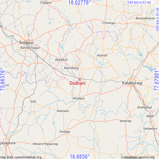
Dudhani GPS coordinates[2]
17° 21' 28.512" North, 76° 22' 0.768" East
| Map corner | latitude | longitude |
|---|---|---|
| Upper-left | 18.02778°, | 75.66376° |
| Center: | 17.35792°, | 76.36688° |
| Lower-right: | 16.6856°, | 77.07001° |
| Map W x H: | 149.2×149.2 km | = 92.7×92.7mi |
| max Lat: | 34.9274° ⇑73.9% North |
| Dudhani: | 17.35792° |
| min Lat: | ⇓26.1% South 8.09008° |
| min Long | Dudhani | max Long |
| 68.82655° | 76.36688° | 96.81° |
| W 30.4%⇐ | ⇒69.6% E |
Elevation
Elevation of Dudhani is 445 m = 1460 ft, and this is 149.4 m = 490 ft above average elevation for this country.
| Max E: |
3681 m = 12077 ft | 21% |
| Dudhani | 445 m 1460 ft | |
| Avg. | 295.6 m = 970 ft | |
Min E: |
1 m = 3 ft | 79% |
See also: India elevation on elevation.city.
Geographical zone
Dudhani is located in North Torrid zone (between Equator and Tropic of Cancer). Distance of this Northern Tropic circle is 675.9 km =420 mi to North.| Distance of | km | miles | from Dudhani |
|---|---|---|---|
| North Pole | 8077 | 5018.8 | to North |
| Arctic Circle | 5471.2 | 3399.6 | to North |
| Tropic Cancer | 675.9 | 420 | to North |
| Equator | 1930 | 1199.2 | to South |


Nearby cities:
15 places around Dudhani: (largest is in red/bold)
• Afzalpur
17.6 km =10.9 mi,  182°
182°
• Akalkot
25.2 km =15.7 mi,  317°
317°
• Aland
31.4 km =19.5 mi,  42°
42°
• Gulbarga
50 km =31.1 mi,  92°
92°
• Indi
48.4 km =30.1 mi,  245°
245°
• Jevargi
57.7 km =35.9 mi,  131°
131°
• Maindargi
13.5 km =8.4 mi, 324°
• Moram
49.1 km =30.5 mi,  12°
12°
• Naldurg
51.8 km =32.2 mi,  349°
349°
• Shāhābād
66.3 km =41.2 mi,  112°
112°
• Sindgi
50.8 km =31.6 mi,  196°
196°
• Solāpur
59.7 km =37.1 mi,  305°
305°
• Tuljāpur
78.8 km =49 mi,  336°
336°
• Umarga
59.9 km =37.2 mi,  26°
26°
• Wādi
74.5 km =46.3 mi,  117°
117°
Sources, notices
• [Note1] Compared only with cities in India existing in our database
• [Src1] Map data: © OpenStreetMap contributors (CC-BY-SA)
• [Src2] Other city data from geonames.org with taken over terms of usage.
• [Src3] Geographical zone / Annual Mean Temperature by Robert A. Rohde @ Wikipedia
