Saraipali geodata
Saraipali (Chhattisgarh) is a populated place; located in India in Asia/Kolkata (GMT+5.5) time zone. With population of 18,394 people, there are 2171 cities with bigger population in this country. Compared to other cities in India, 60% of cities are located further ↑North; 79.3% of cities are located further ←West and 63% of cities have lower elevation than Saraipali. Note1


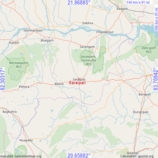
Saraipali GPS coordinates[2]
21° 18' 55.08" North, 83° 0' 22.644" East
| Map corner | latitude | longitude |
|---|---|---|
| Upper-left | 21.96885°, | 82.30317° |
| Center: | 21.3153°, | 83.00629° |
| Lower-right: | 20.65882°, | 83.70942° |
| Map W x H: | 145.7×145.7 km | = 90.5×90.5mi |
| max Lat: | 34.9274° ⇑60% North |
| Saraipali: | 21.3153° |
| min Lat: | ⇓40% South 8.09008° |
| min Long | Saraipali | max Long |
| 68.82655° | 83.00629° | 96.81° |
| W 79.3%⇐ | ⇒20.7% E |
Elevation
Elevation of Saraipali is 271 m = 889 ft, and this is 24.6 m = 81 ft below average elevation for this country.
| Max E: |
3681 m = 12077 ft | 37% |
| Avg. | 295.6 m = 970 ft | |
| Saraipali | 271 m = 889 ft | |
Min E: |
1 m = 3 ft | 63% |
See also: India elevation on elevation.city.
Geographical zone
Saraipali is located in North Torrid zone (between Equator and Tropic of Cancer). Distance of this Northern Tropic circle is 235.9 km =146.6 mi to North.| Distance of | km | miles | from Saraipali |
|---|---|---|---|
| North Pole | 7637 | 4745.4 | to North |
| Arctic Circle | 5031.1 | 3126.2 | to North |
| Tropic Cancer | 235.9 | 146.6 | to North |
| Equator | 2370 | 1472.6 | to South |


Nearby cities:
15 places around Saraipali: (largest is in red/bold)
• Balāngīr
84.5 km =52.5 mi,  143°
143°
• Bargarh
63.5 km =39.5 mi,  88°
88°
• Barpāli
61.8 km =38.4 mi,  103°
103°
• Basna
19 km =11.8 mi,  257°
257°
• Deori
43 km =26.7 mi,  290°
290°
• Khamharia
86.9 km =54 mi,  244°
244°
• Kharod
65 km =40.4 mi,  317°
317°
• Kharsia
75.7 km =47 mi,  7°
7°
• Padampur
35.6 km =22.1 mi,  170°
170°
• Patnāgarh
68.8 km =42.8 mi, 169°
• Pithora
51.2 km =31.8 mi, 261°
• Raigarh
76.3 km =47.4 mi,  31°
31°
• Saktī
79.2 km =49.2 mi,  356°
356°
• Seorīnārāyan
62.1 km =38.6 mi, 316°
• Sārangarh
31 km =19.3 mi, 13°
Sources, notices
• [Note1] Compared only with cities in India existing in our database
• [Src1] Map data: © OpenStreetMap contributors (CC-BY-SA)
• [Src2] Other city data from geonames.org with taken over terms of usage.
• [Src3] Geographical zone / Annual Mean Temperature by Robert A. Rohde @ Wikipedia
