Sārangarh geodata
Sārangarh (Chhattisgarh) is a populated place; located in India in Asia/Kolkata (GMT+5.5) time zone. With population of 14,615 people, there are 2500 cities with bigger population in this country. Compared to other cities in India, 58.6% of cities are located further ↑North; 79.5% of cities are located further ←West and 57.1% of cities have lower elevation than Sārangarh. Note1


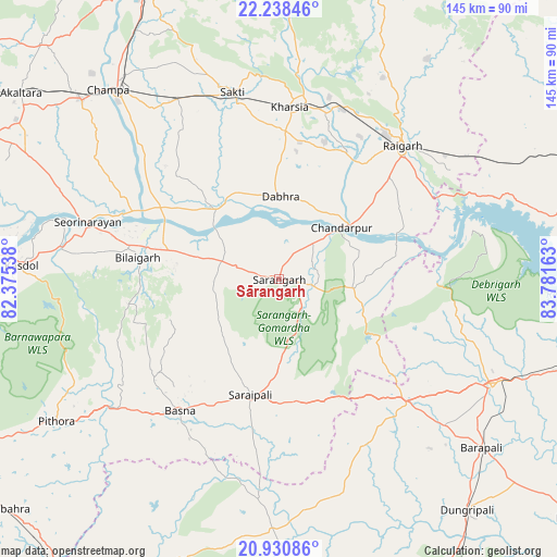
Sārangarh GPS coordinates[2]
21° 35' 10.104" North, 83° 4' 42.6" East
| Map corner | latitude | longitude |
|---|---|---|
| Upper-left | 22.23846°, | 82.37538° |
| Center: | 21.58614°, | 83.0785° |
| Lower-right: | 20.93086°, | 83.78163° |
| Map W x H: | 145.4×145.4 km | = 90.3×90.3mi |
| max Lat: | 34.9274° ⇑58.6% North |
| Sārangarh: | 21.58614° |
| min Lat: | ⇓41.4% South 8.09008° |
| min Long | Sārangarh | max Long |
| 68.82655° | 83.0785° | 96.81° |
| W 79.5%⇐ | ⇒20.5% E |
Elevation
Elevation of Sārangarh is 235 m = 771 ft, and this is 60.6 m = 199 ft below average elevation for this country.
| Max E: |
3681 m = 12077 ft | 42.9% |
| Avg. | 295.6 m = 970 ft | |
| Sārangarh | 235 m = 771 ft | |
Min E: |
1 m = 3 ft | 57.1% |
See also: India elevation on elevation.city.
Geographical zone
Sārangarh is located in North Torrid zone (between Equator and Tropic of Cancer). Distance of this Northern Tropic circle is 205.8 km =127.9 mi to North.| Distance of | km | miles | from Sārangarh |
|---|---|---|---|
| North Pole | 7606.9 | 4726.7 | to North |
| Arctic Circle | 5001 | 3107.5 | to North |
| Tropic Cancer | 205.8 | 127.9 | to North |
| Equator | 2400.2 | 1491.4 | to South |


Nearby cities:
15 places around Sārangarh: (largest is in red/bold)
• Bargarh
62.6 km =38.9 mi,  116°
116°
• Barpāli
68.7 km =42.7 mi,  129°
129°
• Basna
43 km =26.7 mi,  217°
217°
• Chāmpa
67.2 km =41.8 mi,  317°
317°
• Deori
50.1 km =31.1 mi,  252°
252°
• Gharghoda
71.2 km =44.2 mi,  23°
23°
• Jānjgīr
69.9 km =43.4 mi,  312°
312°
• Kharod
54.5 km =33.9 mi,  288°
288°
• Kharsia
44.9 km =27.9 mi,  3°
3°
• Padampur
65.3 km =40.6 mi,  181°
181°
• Pithora
69.1 km =42.9 mi,  237°
237°
• Raigarh
47.7 km =29.6 mi,  43°
43°
• Saktī
50.5 km =31.4 mi,  346°
346°
• Saraipali
31 km =19.3 mi,  193°
193°
• Seorīnārāyan
52.3 km =32.5 mi, 286°
Sources, notices
• [Note1] Compared only with cities in India existing in our database
• [Src1] Map data: © OpenStreetMap contributors (CC-BY-SA)
• [Src2] Other city data from geonames.org with taken over terms of usage.
• [Src3] Geographical zone / Annual Mean Temperature by Robert A. Rohde @ Wikipedia
