Saktī geodata
Saktī (Chhattisgarh) is a populated place; located in India in Asia/Kolkata (GMT+5.5) time zone. With population of 21,561 people, there are 1931 cities with bigger population in this country. Compared to other cities in India, 56.6% of cities are located further ↑North; 79.2% of cities are located further ←West and 59.2% of cities have lower elevation than Saktī. Note1


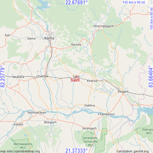
Saktī GPS coordinates[2]
22° 1' 35.832" North, 82° 57' 39.276" East
| Map corner | latitude | longitude |
|---|---|---|
| Upper-left | 22.67691°, | 82.25779° |
| Center: | 22.02662°, | 82.96091° |
| Lower-right: | 21.37333°, | 83.66404° |
| Map W x H: | 144.9×144.9 km | = 90×90mi |
| max Lat: | 34.9274° ⇑56.6% North |
| Saktī: | 22.02662° |
| min Lat: | ⇓43.4% South 8.09008° |
| min Long | Saktī | max Long |
| 68.82655° | 82.96091° | 96.81° |
| W 79.2%⇐ | ⇒20.8% E |
Elevation
Elevation of Saktī is 245 m = 804 ft, and this is 50.6 m = 166 ft below average elevation for this country.
| Max E: |
3681 m = 12077 ft | 40.8% |
| Avg. | 295.6 m = 970 ft | |
| Saktī | 245 m = 804 ft | |
Min E: |
1 m = 3 ft | 59.2% |
See also: India elevation on elevation.city.
Geographical zone
Saktī is located in North Torrid zone (between Equator and Tropic of Cancer). Distance of this Northern Tropic circle is 156.8 km =97.4 mi to North.| Distance of | km | miles | from Saktī |
|---|---|---|---|
| North Pole | 7557.9 | 4696.3 | to North |
| Arctic Circle | 4952 | 3077 | to North |
| Tropic Cancer | 156.8 | 97.4 | to North |
| Equator | 2449.1 | 1521.8 | to South |


Nearby cities:
15 places around Saktī: (largest is in red/bold)
• Akaltara
55.1 km =34.2 mi,  269°
269°
• Baloda
50.9 km =31.6 mi,  284°
284°
• Chāmpa
32.8 km =20.4 mi, 271°
• Deori
73.3 km =45.5 mi,  209°
209°
• Gharghoda
43.5 km =27 mi,  67°
67°
• Jānjgīr
39.5 km =24.5 mi, 267°
• Katghora
68.2 km =42.4 mi,  320°
320°
• Kharod
50.4 km =31.3 mi,  231°
231°
• Kharsia
15.4 km =9.6 mi,  105°
105°
• Korba
44.7 km =27.8 mi, 322°
• Pathalgaon
78.4 km =48.7 mi,  41°
41°
• Raigarh
47.2 km =29.3 mi, 107°
• Saraipali
79.2 km =49.2 mi,  176°
176°
• Seorīnārāyan
50.9 km =31.6 mi, 228°
• Sārangarh
50.5 km =31.4 mi,  166°
166°
Sources, notices
• [Note1] Compared only with cities in India existing in our database
• [Src1] Map data: © OpenStreetMap contributors (CC-BY-SA)
• [Src2] Other city data from geonames.org with taken over terms of usage.
• [Src3] Geographical zone / Annual Mean Temperature by Robert A. Rohde @ Wikipedia
