Sāngola geodata
Sāngola (Maharashtra) is a populated place; located in India in Asia/Kolkata (GMT+5.5) time zone. With population of 31,279 people, there are 1387 cities with bigger population in this country. Compared to other cities in India, 73.7% of cities are located further ↑North; 81.1% of cities are located further →East and 82.6% of cities have lower elevation than Sāngola. Note1


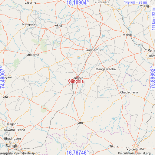
Sāngola GPS coordinates[2]
17° 26' 22.128" North, 75° 11' 37.644" East
| Map corner | latitude | longitude |
|---|---|---|
| Upper-left | 18.10904°, | 74.49067° |
| Center: | 17.43948°, | 75.19379° |
| Lower-right: | 16.76746°, | 75.89692° |
| Map W x H: | 149.2×149.2 km | = 92.7×92.7mi |
| max Lat: | 34.9274° ⇑73.7% North |
| Sāngola: | 17.43948° |
| min Lat: | ⇓26.3% South 8.09008° |
| min Long | Sāngola | max Long |
| 68.82655° | 75.19379° | 96.81° |
| W 18.9%⇐ | ⇒81.1% E |
Elevation
Elevation of Sāngola is 502 m = 1647 ft, and this is 206.4 m = 677 ft above average elevation for this country.
| Max E: |
3681 m = 12077 ft | 17.4% |
| Sāngola | 502 m 1647 ft | |
| Avg. | 295.6 m = 970 ft | |
Min E: |
1 m = 3 ft | 82.6% |
See also: India elevation on elevation.city.
Geographical zone
Sāngola is located in North Torrid zone (between Equator and Tropic of Cancer). Distance of this Northern Tropic circle is 666.8 km =414.3 mi to North.| Distance of | km | miles | from Sāngola |
|---|---|---|---|
| North Pole | 8068 | 5013.2 | to North |
| Arctic Circle | 5462.1 | 3394 | to North |
| Tropic Cancer | 666.8 | 414.3 | to North |
| Equator | 1939.1 | 1204.9 | to South |


Nearby cities:
15 places around Sāngola: (largest is in red/bold)
• Ashta
99.6 km =61.9 mi,  236°
236°
• Athni
80.5 km =50 mi,  189°
189°
• Bhudgaon
86.5 km =53.7 mi,  226°
226°
• Bijapur
88 km =54.7 mi,  140°
140°
• Indi
85.7 km =53.3 mi,  109°
109°
• Kalas
92 km =57.2 mi,  332°
332°
• Kudachi
97.2 km =60.4 mi,  201°
201°
• Kurduvādi
76.4 km =47.5 mi,  17°
17°
• Kāti
93.8 km =58.3 mi,  51°
51°
• Mhāsvād
48.2 km =30 mi,  296°
296°
• Pandharpur
30.4 km =18.9 mi,  28°
28°
• Solāpur
80.2 km =49.8 mi,  71°
71°
• Sāngli
93.3 km =58 mi, 225°
• Tāsgaon
77.2 km =48 mi, 234°
• Vite
72 km =44.7 mi,  255°
255°
Sources, notices
• [Note1] Compared only with cities in India existing in our database
• [Src1] Map data: © OpenStreetMap contributors (CC-BY-SA)
• [Src2] Other city data from geonames.org with taken over terms of usage.
• [Src3] Geographical zone / Annual Mean Temperature by Robert A. Rohde @ Wikipedia
