Solāpur geodata
Solāpur (Maharashtra) is a populated place; located in India in Asia/Kolkata (GMT+5.5) time zone. With population of 997,281 people, there are 42 cities with bigger population in this country. Compared to other cities in India, 72.6% of cities are located further ↑North; 74.6% of cities are located further →East and 80.9% of cities have lower elevation than Solāpur. Note1


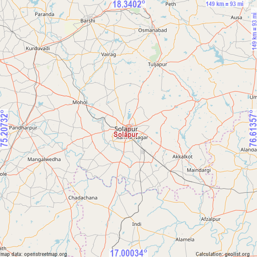
Solāpur GPS coordinates[2]
17° 40' 17.472" North, 75° 54' 37.584" East
| Map corner | latitude | longitude |
|---|---|---|
| Upper-left | 18.3402°, | 75.20732° |
| Center: | 17.67152°, | 75.91044° |
| Lower-right: | 17.00034°, | 76.61357° |
| Map W x H: | 149×149 km | = 92.6×92.6mi |
| max Lat: | 34.9274° ⇑72.6% North |
| Solāpur: | 17.67152° |
| min Lat: | ⇓27.4% South 8.09008° |
| min Long | Solāpur | max Long |
| 68.82655° | 75.91044° | 96.81° |
| W 25.4%⇐ | ⇒74.6% E |
Elevation
Elevation of Solāpur is 473 m = 1552 ft, and this is 177.4 m = 582 ft above average elevation for this country.
| Max E: |
3681 m = 12077 ft | 19.1% |
| Solāpur | 473 m 1552 ft | |
| Avg. | 295.6 m = 970 ft | |
Min E: |
1 m = 3 ft | 80.9% |
See also: Solāpur elevation on elevation.city.
Geographical zone
Solāpur is located in North Torrid zone (between Equator and Tropic of Cancer). Distance of this Northern Tropic circle is 641 km =398.3 mi to North.| Distance of | km | miles | from Solāpur |
|---|---|---|---|
| North Pole | 8042.2 | 4997.2 | to North |
| Arctic Circle | 5436.3 | 3378 | to North |
| Tropic Cancer | 641 | 398.3 | to North |
| Equator | 1964.9 | 1220.9 | to South |


Nearby cities:
15 places around Solāpur: (largest is in red/bold)
• Afzalpur
70.9 km =44.1 mi,  137°
137°
• Akalkot
35.3 km =21.9 mi,  117°
117°
• Aland
70.8 km =44 mi,  99°
99°
• Bārsi
66.7 km =41.4 mi,  339°
339°
• Dudhani
59.7 km =37.1 mi,  125°
125°
• Indi
55.1 km =34.2 mi,  175°
175°
• Kurduvādi
70.3 km =43.7 mi,  311°
311°
• Kāti
32.3 km =20.1 mi,  355°
355°
• Maindargi
47 km =29.2 mi, 120°
• Moram
60.7 km =37.7 mi,  77°
77°
• Naldurg
42.5 km =26.4 mi,  67°
67°
• Osmanabad
58.3 km =36.2 mi,  13°
13°
• Pandharpur
61.4 km =38.2 mi,  270°
270°
• Tuljāpur
41.1 km =25.5 mi,  24°
24°
• Umarga
77.7 km =48.3 mi, 76°
Sources, notices
• [Note1] Compared only with cities in India existing in our database
• [Src1] Map data: © OpenStreetMap contributors (CC-BY-SA)
• [Src2] Other city data from geonames.org with taken over terms of usage.
• [Src3] Geographical zone / Annual Mean Temperature by Robert A. Rohde @ Wikipedia
