Mhāsvād geodata
Mhāsvād (Maharashtra) is a populated place; located in India in Asia/Kolkata (GMT+5.5) time zone. With population of 21,404 people, there are 1940 cities with bigger population in this country. Compared to other cities in India, 72.7% of cities are located further ↑North; 84.4% of cities are located further →East and 88.9% of cities have lower elevation than Mhāsvād. Note1


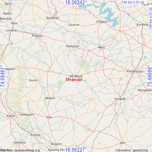
Mhāsvād GPS coordinates[2]
17° 38' 0.924" North, 74° 47' 15.828" East
| Map corner | latitude | longitude |
|---|---|---|
| Upper-left | 18.30242°, | 74.08461° |
| Center: | 17.63359°, | 74.78773° |
| Lower-right: | 16.96227°, | 75.49086° |
| Map W x H: | 149×149 km | = 92.6×92.6mi |
| max Lat: | 34.9274° ⇑72.7% North |
| Mhāsvād: | 17.63359° |
| min Lat: | ⇓27.3% South 8.09008° |
| min Long | Mhāsvād | max Long |
| 68.82655° | 74.78773° | 96.81° |
| W 15.6%⇐ | ⇒84.4% E |
Elevation
Elevation of Mhāsvād is 609 m = 1998 ft, and this is 313.4 m = 1028 ft above average elevation for this country.
| Max E: |
3681 m = 12077 ft | 11.1% |
| Mhāsvād | 609 m 1998 ft | |
| Avg. | 295.6 m = 970 ft | |
Min E: |
1 m = 3 ft | 88.9% |
See also: India elevation on elevation.city.
Geographical zone
Mhāsvād is located in North Torrid zone (between Equator and Tropic of Cancer). Distance of this Northern Tropic circle is 645.2 km =400.9 mi to North.| Distance of | km | miles | from Mhāsvād |
|---|---|---|---|
| North Pole | 8046.4 | 4999.8 | to North |
| Arctic Circle | 5440.5 | 3380.6 | to North |
| Tropic Cancer | 645.2 | 400.9 | to North |
| Equator | 1960.7 | 1218.3 | to South |


Nearby cities:
15 places around Mhāsvād: (largest is in red/bold)
• Ashta
86 km =53.4 mi,  207°
207°
• Bhigvan
74.2 km =46.1 mi,  358°
358°
• Bhudgaon
83.2 km =51.7 mi,  193°
193°
• Bārāmati
61.8 km =38.4 mi,  338°
338°
• Kalas
59.9 km =37.2 mi,  0°
0°
• Karād
74.8 km =46.5 mi,  239°
239°
• Kurduvādi
83.8 km =52.1 mi,  52°
52°
• Malkapur
76.9 km =47.8 mi, 237°
• Pandharpur
57.8 km =35.9 mi,  84°
84°
• Phaltan
54.8 km =34.1 mi,  316°
316°
• Rahimatpur
62.5 km =38.8 mi,  265°
265°
• Satara
84.4 km =52.4 mi, 273°
• Sāngola
48.2 km =30 mi,  116°
116°
• Tāsgaon
69.2 km =43 mi,  196°
196°
• Vite
48 km =29.8 mi, 213°
Sources, notices
• [Note1] Compared only with cities in India existing in our database
• [Src1] Map data: © OpenStreetMap contributors (CC-BY-SA)
• [Src2] Other city data from geonames.org with taken over terms of usage.
• [Src3] Geographical zone / Annual Mean Temperature by Robert A. Rohde @ Wikipedia
