Pandharpur geodata
Pandharpur (Maharashtra) is a populated place; located in India in Asia/Kolkata (GMT+5.5) time zone. With population of 95,665 people, there are 465 cities with bigger population in this country. Compared to other cities in India, 72.6% of cities are located further ↑North; 79.9% of cities are located further →East and 79.8% of cities have lower elevation than Pandharpur. Note1


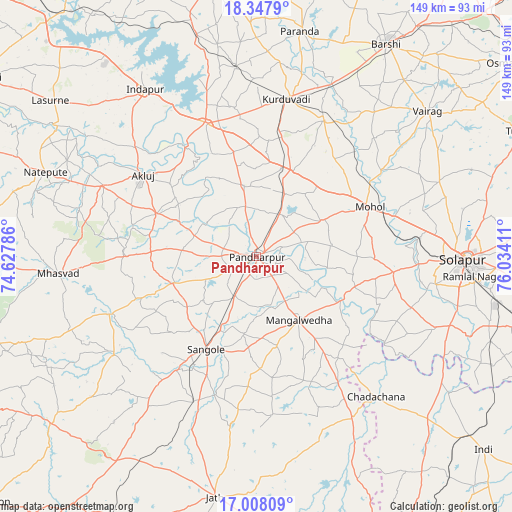
Pandharpur GPS coordinates[2]
17° 40' 45.264" North, 75° 19' 51.528" East
| Map corner | latitude | longitude |
|---|---|---|
| Upper-left | 18.3479°, | 74.62786° |
| Center: | 17.67924°, | 75.33098° |
| Lower-right: | 17.00809°, | 76.03411° |
| Map W x H: | 149×149 km | = 92.6×92.6mi |
| max Lat: | 34.9274° ⇑72.6% North |
| Pandharpur: | 17.67924° |
| min Lat: | ⇓27.4% South 8.09008° |
| min Long | Pandharpur | max Long |
| 68.82655° | 75.33098° | 96.81° |
| W 20.1%⇐ | ⇒79.9% E |
Elevation
Elevation of Pandharpur is 456 m = 1496 ft, and this is 160.4 m = 526 ft above average elevation for this country.
| Max E: |
3681 m = 12077 ft | 20.2% |
| Pandharpur | 456 m 1496 ft | |
| Avg. | 295.6 m = 970 ft | |
Min E: |
1 m = 3 ft | 79.8% |
See also: Pandharpur elevation on elevation.city.
Geographical zone
Pandharpur is located in North Torrid zone (between Equator and Tropic of Cancer). Distance of this Northern Tropic circle is 640.2 km =397.8 mi to North.| Distance of | km | miles | from Pandharpur |
|---|---|---|---|
| North Pole | 8041.3 | 4996.6 | to North |
| Arctic Circle | 5435.4 | 3377.4 | to North |
| Tropic Cancer | 640.2 | 397.8 | to North |
| Equator | 1965.7 | 1221.4 | to South |


Nearby cities:
15 places around Pandharpur: (largest is in red/bold)
• Akalkot
94.3 km =58.6 mi,  100°
100°
• Bhigvan
91.3 km =56.7 mi,  319°
319°
• Bhūm
93.4 km =58 mi,  21°
21°
• Bārsi
72.6 km =45.1 mi,  31°
31°
• Indi
86.4 km =53.7 mi,  130°
130°
• Kalas
79.2 km =49.2 mi,  313°
313°
• Karmāla
82.3 km =51.1 mi,  349°
349°
• Kurduvādi
46.9 km =29.1 mi,  11°
11°
• Kāti
66.9 km =41.6 mi,  62°
62°
• Mhāsvād
57.8 km =35.9 mi,  264°
264°
• Osmanabad
93.4 km =58 mi,  53°
53°
• Solāpur
61.4 km =38.2 mi,  90°
90°
• Sāngola
30.4 km =18.9 mi,  208°
208°
• Tuljāpur
86.4 km =53.7 mi, 64°
• Vite
95.4 km =59.3 mi,  241°
241°
Sources, notices
• [Note1] Compared only with cities in India existing in our database
• [Src1] Map data: © OpenStreetMap contributors (CC-BY-SA)
• [Src2] Other city data from geonames.org with taken over terms of usage.
• [Src3] Geographical zone / Annual Mean Temperature by Robert A. Rohde @ Wikipedia
