Indi geodata
Indi (Karnataka) is a populated place; located in India in Asia/Kolkata (GMT+5.5) time zone. With population of 34,075 people, there are 1277 cities with bigger population in this country. Compared to other cities in India, 74.4% of cities are located further ↑North; 74% of cities are located further →East and 80.4% of cities have lower elevation than Indi. Note1


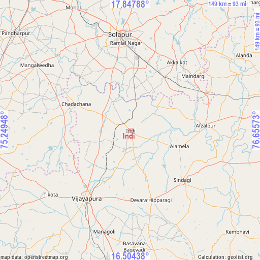
Indi GPS coordinates[2]
17° 10' 38.46" North, 75° 57' 9.36" East
| Map corner | latitude | longitude |
|---|---|---|
| Upper-left | 17.84788°, | 75.24948° |
| Center: | 17.17735°, | 75.9526° |
| Lower-right: | 16.50438°, | 76.65573° |
| Map W x H: | 149.4×149.4 km | = 92.8×92.8mi |
| max Lat: | 34.9274° ⇑74.4% North |
| Indi: | 17.17735° |
| min Lat: | ⇓25.6% South 8.09008° |
| min Long | Indi | max Long |
| 68.82655° | 75.9526° | 96.81° |
| W 26%⇐ | ⇒74% E |
Elevation
Elevation of Indi is 466 m = 1529 ft, and this is 170.4 m = 559 ft above average elevation for this country.
| Max E: |
3681 m = 12077 ft | 19.6% |
| Indi | 466 m 1529 ft | |
| Avg. | 295.6 m = 970 ft | |
Min E: |
1 m = 3 ft | 80.4% |
See also: India elevation on elevation.city.
Geographical zone
Indi is located in North Torrid zone (between Equator and Tropic of Cancer). Distance of this Northern Tropic circle is 696 km =432.5 mi to North.| Distance of | km | miles | from Indi |
|---|---|---|---|
| North Pole | 8097.1 | 5031.3 | to North |
| Arctic Circle | 5491.2 | 3412.1 | to North |
| Tropic Cancer | 696 | 432.5 | to North |
| Equator | 1909.9 | 1186.8 | to South |


Nearby cities:
15 places around Indi: (largest is in red/bold)
• Afzalpur
43.4 km =27 mi,  86°
86°
• Akalkot
47.1 km =29.3 mi,  34°
34°
• Aland
78.2 km =48.6 mi,  56°
56°
• Basavana Bāgevādi
67.3 km =41.8 mi,  178°
178°
• Bijapur
46.7 km =29 mi,  212°
212°
• Dudhani
48.4 km =30.1 mi,  65°
65°
• Kāti
87.4 km =54.3 mi,  355°
355°
• Maindargi
47.7 km =29.6 mi,  49°
49°
• Moram
87.4 km =54.3 mi,  38°
38°
• Naldurg
79.2 km =49.2 mi, 26°
• Pandharpur
86.4 km =53.7 mi,  310°
310°
• Sindgi
41.5 km =25.8 mi,  133°
133°
• Solāpur
55.1 km =34.2 mi, 355°
• Sāngola
85.7 km =53.3 mi,  289°
289°
• Tālīkota
87.1 km =54.1 mi,  154°
154°
Sources, notices
• [Note1] Compared only with cities in India existing in our database
• [Src1] Map data: © OpenStreetMap contributors (CC-BY-SA)
• [Src2] Other city data from geonames.org with taken over terms of usage.
• [Src3] Geographical zone / Annual Mean Temperature by Robert A. Rohde @ Wikipedia
