Kalas geodata
Kalas (Maharashtra) is a populated place; located in India in Asia/Kolkata (GMT+5.5) time zone. With population of 14,858 people, there are 2476 cities with bigger population in this country. Compared to other cities in India, 71.3% of cities are located further ↑North; 84.4% of cities are located further →East and 85.9% of cities have lower elevation than Kalas. Note1


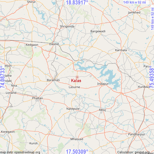
Kalas GPS coordinates[2]
18° 10' 20.676" North, 74° 47' 25.62" East
| Map corner | latitude | longitude |
|---|---|---|
| Upper-left | 18.83917°, | 74.08733° |
| Center: | 18.17241°, | 74.79045° |
| Lower-right: | 17.50309°, | 75.49358° |
| Map W x H: | 148.6×148.6 km | = 92.3×92.3mi |
| max Lat: | 34.9274° ⇑71.3% North |
| Kalas: | 18.17241° |
| min Lat: | ⇓28.7% South 8.09008° |
| min Long | Kalas | max Long |
| 68.82655° | 74.79045° | 96.81° |
| W 15.6%⇐ | ⇒84.4% E |
Elevation
Elevation of Kalas is 560 m = 1837 ft, and this is 264.4 m = 867 ft above average elevation for this country.
| Max E: |
3681 m = 12077 ft | 14.1% |
| Kalas | 560 m 1837 ft | |
| Avg. | 295.6 m = 970 ft | |
Min E: |
1 m = 3 ft | 85.9% |
See also: India elevation on elevation.city.
Geographical zone
Kalas is located in North Torrid zone (between Equator and Tropic of Cancer). Distance of this Northern Tropic circle is 585.3 km =363.7 mi to North.| Distance of | km | miles | from Kalas |
|---|---|---|---|
| North Pole | 7986.5 | 4962.6 | to North |
| Arctic Circle | 5380.6 | 3343.3 | to North |
| Tropic Cancer | 585.3 | 363.7 | to North |
| Equator | 2020.6 | 1255.5 | to South |


Nearby cities:
15 places around Kalas: (largest is in red/bold)
• Bhigvan
14.5 km =9 mi,  350°
350°
• Bārāmati
22.6 km =14 mi,  264°
264°
• Daund
39.2 km =24.4 mi,  326°
326°
• Jejūri
67.6 km =42 mi,  279°
279°
• Karmāla
50 km =31.1 mi,  58°
58°
• Kurduvādi
66.6 km =41.4 mi,  97°
97°
• Mhāsvād
59.9 km =37.2 mi,  180°
180°
• Pandharpur
79.2 km =49.2 mi,  133°
133°
• Phaltan
42.9 km =26.7 mi,  242°
242°
• Rahimatpur
89.8 km =55.8 mi,  224°
224°
• Shirwal
85.9 km =53.4 mi,  268°
268°
• Shrīgonda
50.2 km =31.2 mi, 348°
• Sirūr
85 km =52.8 mi, 328°
• Sāngola
92 km =57.2 mi,  152°
152°
• Sāsvad
82.4 km =51.2 mi, 283°
Sources, notices
• [Note1] Compared only with cities in India existing in our database
• [Src1] Map data: © OpenStreetMap contributors (CC-BY-SA)
• [Src2] Other city data from geonames.org with taken over terms of usage.
• [Src3] Geographical zone / Annual Mean Temperature by Robert A. Rohde @ Wikipedia
