Kurduvādi geodata
Kurduvādi (Maharashtra) is a populated place; located in India in Asia/Kolkata (GMT+5.5) time zone. With population of 23,131 people, there are 1828 cities with bigger population in this country. Compared to other cities in India, 71.6% of cities are located further ↑North; 79.1% of cities are located further →East and 83.5% of cities have lower elevation than Kurduvādi. Note1


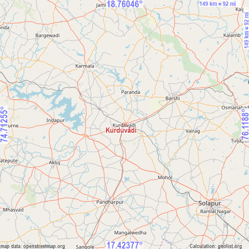
Kurduvādi GPS coordinates[2]
18° 5' 36.204" North, 75° 24' 56.412" East
| Map corner | latitude | longitude |
|---|---|---|
| Upper-left | 18.76046°, | 74.71255° |
| Center: | 18.09339°, | 75.41567° |
| Lower-right: | 17.42377°, | 76.1188° |
| Map W x H: | 148.6×148.6 km | = 92.3×92.3mi |
| max Lat: | 34.9274° ⇑71.6% North |
| Kurduvādi: | 18.09339° |
| min Lat: | ⇓28.4% South 8.09008° |
| min Long | Kurduvādi | max Long |
| 68.82655° | 75.41567° | 96.81° |
| W 20.9%⇐ | ⇒79.1% E |
Elevation
Elevation of Kurduvādi is 516 m = 1693 ft, and this is 220.4 m = 723 ft above average elevation for this country.
| Max E: |
3681 m = 12077 ft | 16.5% |
| Kurduvādi | 516 m 1693 ft | |
| Avg. | 295.6 m = 970 ft | |
Min E: |
1 m = 3 ft | 83.5% |
See also: India elevation on elevation.city.
Geographical zone
Kurduvādi is located in North Torrid zone (between Equator and Tropic of Cancer). Distance of this Northern Tropic circle is 594.1 km =369.2 mi to North.| Distance of | km | miles | from Kurduvādi |
|---|---|---|---|
| North Pole | 7995.3 | 4968 | to North |
| Arctic Circle | 5389.4 | 3348.8 | to North |
| Tropic Cancer | 594.1 | 369.2 | to North |
| Equator | 2011.8 | 1250.1 | to South |


Nearby cities:
15 places around Kurduvādi: (largest is in red/bold)
• Bhigvan
72.3 km =44.9 mi,  288°
288°
• Bhūm
48.1 km =29.9 mi,  32°
32°
• Bārsi
33.2 km =20.6 mi,  61°
61°
• Bārāmati
88.8 km =55.2 mi,  274°
274°
• Kalas
66.6 km =41.4 mi,  277°
277°
• Karmāla
42.1 km =26.2 mi,  326°
326°
• Kāti
52.1 km =32.4 mi,  106°
106°
• Mhāsvād
83.8 km =52.1 mi,  232°
232°
• Naldurg
96.6 km =60 mi, 108°
• Osmanabad
66.6 km =41.4 mi,  81°
81°
• Pandharpur
46.9 km =29.1 mi,  191°
191°
• Shrīgonda
95.3 km =59.2 mi,  307°
307°
• Solāpur
70.3 km =43.7 mi,  131°
131°
• Sāngola
76.4 km =47.5 mi,  197°
197°
• Tuljāpur
69.8 km =43.4 mi,  97°
97°
Sources, notices
• [Note1] Compared only with cities in India existing in our database
• [Src1] Map data: © OpenStreetMap contributors (CC-BY-SA)
• [Src2] Other city data from geonames.org with taken over terms of usage.
• [Src3] Geographical zone / Annual Mean Temperature by Robert A. Rohde @ Wikipedia
