Rāhuri geodata
Rāhuri (Maharashtra) is a populated place; located in India in Asia/Kolkata (GMT+5.5) time zone. With population of 36,885 people, there are 1189 cities with bigger population in this country. Compared to other cities in India, 67.2% of cities are located further ↑North; 85.6% of cities are located further →East and 83.2% of cities have lower elevation than Rāhuri. Note1


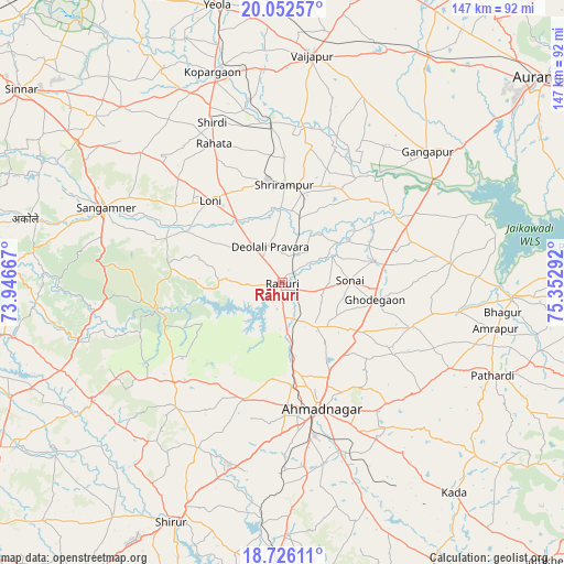
Rāhuri GPS coordinates[2]
19° 23' 26.484" North, 74° 38' 59.244" East
| Map corner | latitude | longitude |
|---|---|---|
| Upper-left | 20.05257°, | 73.94667° |
| Center: | 19.39069°, | 74.64979° |
| Lower-right: | 18.72611°, | 75.35292° |
| Map W x H: | 147.5×147.5 km | = 91.7×91.7mi |
| max Lat: | 34.9274° ⇑67.2% North |
| Rāhuri: | 19.39069° |
| min Lat: | ⇓32.8% South 8.09008° |
| min Long | Rāhuri | max Long |
| 68.82655° | 74.64979° | 96.81° |
| W 14.4%⇐ | ⇒85.6% E |
Elevation
Elevation of Rāhuri is 511 m = 1677 ft, and this is 215.4 m = 707 ft above average elevation for this country.
| Max E: |
3681 m = 12077 ft | 16.8% |
| Rāhuri | 511 m 1677 ft | |
| Avg. | 295.6 m = 970 ft | |
Min E: |
1 m = 3 ft | 83.2% |
See also: India elevation on elevation.city.
Geographical zone
Rāhuri is located in North Torrid zone (between Equator and Tropic of Cancer). Distance of this Northern Tropic circle is 449.9 km =279.6 mi to North.| Distance of | km | miles | from Rāhuri |
|---|---|---|---|
| North Pole | 7851 | 4878.4 | to North |
| Arctic Circle | 5245.1 | 3259.2 | to North |
| Tropic Cancer | 449.9 | 279.6 | to North |
| Equator | 2156 | 1339.7 | to South |


Nearby cities:
15 places around Rāhuri: (largest is in red/bold)
• Ahmadnagar
34.2 km =21.3 mi,  164°
164°
• Daulatābād
85.2 km =52.9 mi,  44°
44°
• Gangāpur
50.9 km =31.6 mi,  47°
47°
• Junnar
83.8 km =52.1 mi,  255°
255°
• Kalamb
82.4 km =51.2 mi,  242°
242°
• Kopargaon
57.6 km =35.8 mi,  341°
341°
• Paithan
77.7 km =48.3 mi,  83°
83°
• Pāthardi
60.1 km =37.3 mi,  113°
113°
• Sangamner
50 km =31.1 mi,  293°
293°
• Shirdi
45.5 km =28.3 mi, 336°
• Sinnar
84.9 km =52.8 mi,  306°
306°
• Sirūr
69 km =42.9 mi,  204°
204°
• Vaijāpur
60.2 km =37.4 mi,  7°
7°
• Yeola
74.4 km =46.2 mi,  346°
346°
• Ārangaon
41 km =25.5 mi,  170°
170°
Sources, notices
• [Note1] Compared only with cities in India existing in our database
• [Src1] Map data: © OpenStreetMap contributors (CC-BY-SA)
• [Src2] Other city data from geonames.org with taken over terms of usage.
• [Src3] Geographical zone / Annual Mean Temperature by Robert A. Rohde @ Wikipedia
