Jaithāri geodata
Jaithāri (Madhya Pradesh) is a populated place; located in India in Asia/Kolkata (GMT+5.5) time zone. With population of 8,386 people, there are 3090 cities with bigger population in this country. Compared to other cities in India, 53% of cities are located further ↓South; 55.3% of cities are located further ←West and 75.6% of cities have lower elevation than Jaithāri. Note1


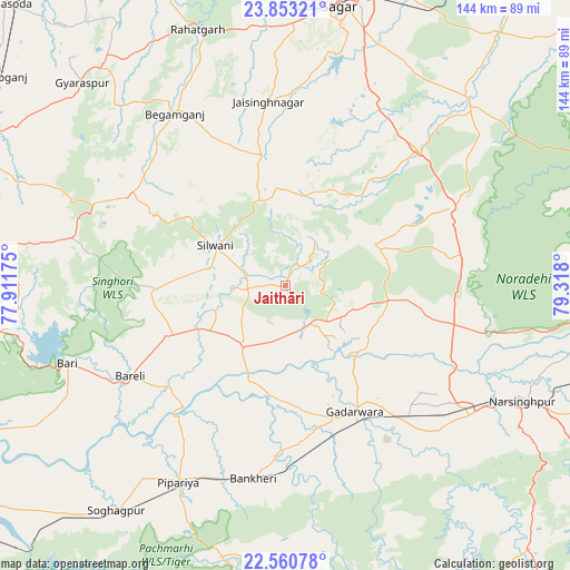
Jaithāri GPS coordinates[2]
23° 12' 30.816" North, 78° 36' 53.532" East
| Map corner | latitude | longitude |
|---|---|---|
| Upper-left | 23.85321°, | 77.91175° |
| Center: | 23.20856°, | 78.61487° |
| Lower-right: | 22.56078°, | 79.318° |
| Map W x H: | 143.7×143.7 km | = 89.3×89.3mi |
| max Lat: | 34.9274° ⇑47% North |
| Jaithāri: | 23.20856° |
| min Lat: | ⇓53% South 8.09008° |
| min Long | Jaithāri | max Long |
| 68.82655° | 78.61487° | 96.81° |
| W 55.3%⇐ | ⇒44.7% E |
Elevation
Elevation of Jaithāri is 394 m = 1293 ft, and this is 98.4 m = 323 ft above average elevation for this country.
| Max E: |
3681 m = 12077 ft | 24.4% |
| Jaithāri | 394 m 1293 ft | |
| Avg. | 295.6 m = 970 ft | |
Min E: |
1 m = 3 ft | 75.6% |
See also: India elevation on elevation.city.
Geographical zone
Jaithāri is located in North Torrid zone (between Equator and Tropic of Cancer). Distance of this Northern Tropic circle is 25.4 km =15.8 mi to North.| Distance of | km | miles | from Jaithāri |
|---|---|---|---|
| North Pole | 7426.5 | 4614.6 | to North |
| Arctic Circle | 4820.6 | 2995.4 | to North |
| Tropic Cancer | 25.4 | 15.8 | to North |
| Equator | 2580.5 | 1603.4 | to South |


Nearby cities:
15 places around Jaithāri: (largest is in red/bold)
• Begamganj
51.7 km =32.1 mi,  327°
327°
• Chichli
47 km =29.2 mi,  152°
152°
• Deori Khās
45.7 km =28.4 mi,  63°
63°
• Dhāna
65 km =40.4 mi,  22°
22°
• Garhākota
83.2 km =51.7 mi,  40°
40°
• Gādarwāra
36.2 km =22.5 mi, 151°
• Kareli
56.3 km =35 mi,  125°
125°
• Narsimhapur
64.9 km =40.3 mi,  116°
116°
• Pachmarhi
84.4 km =52.4 mi,  192°
192°
• Rehli
66 km =41 mi, 43°
• Rāhatgarh
68.4 km =42.5 mi,  340°
340°
• Saugor
71.2 km =44.2 mi,  10°
10°
• Sohāgpur
71 km =44.1 mi,  217°
217°
• Sultānpur
70 km =43.5 mi,  263°
263°
• Udaipura
18.3 km =11.4 mi, 215°
Sources, notices
• [Note1] Compared only with cities in India existing in our database
• [Src1] Map data: © OpenStreetMap contributors (CC-BY-SA)
• [Src2] Other city data from geonames.org with taken over terms of usage.
• [Src3] Geographical zone / Annual Mean Temperature by Robert A. Rohde @ Wikipedia
