Punganūru geodata
Punganūru (Andhra Pradesh) is a populated place; located in India in Asia/Kolkata (GMT+5.5) time zone. With population of 48,865 people, there are 903 cities with bigger population in this country. Compared to other cities in India, 84.7% of cities are located further ↑North; 54.8% of cities are located further ←West and 92.7% of cities have lower elevation than Punganūru. Note1


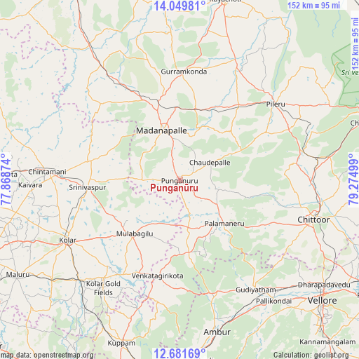
Punganūru GPS coordinates[2]
13° 22' 0.192" North, 78° 34' 18.696" East
| Map corner | latitude | longitude |
|---|---|---|
| Upper-left | 14.04981°, | 77.86874° |
| Center: | 13.36672°, | 78.57186° |
| Lower-right: | 12.68169°, | 79.27499° |
| Map W x H: | 152.1×152.1 km | = 94.5×94.5mi |
| max Lat: | 34.9274° ⇑84.7% North |
| Punganūru: | 13.36672° |
| min Lat: | ⇓15.3% South 8.09008° |
| min Long | Punganūru | max Long |
| 68.82655° | 78.57186° | 96.81° |
| W 54.8%⇐ | ⇒45.2% E |
Elevation
Elevation of Punganūru is 730 m = 2395 ft, and this is 434.4 m = 1425 ft above average elevation for this country.
| Max E: |
3681 m = 12077 ft | 7.3% |
| Punganūru | 730 m 2395 ft | |
| Avg. | 295.6 m = 970 ft | |
Min E: |
1 m = 3 ft | 92.7% |
See also: Punganūru elevation on elevation.city.
Geographical zone
Punganūru is located in North Torrid zone (between Equator and Tropic of Cancer). Distance of this Northern Tropic circle is 1119.7 km =695.7 mi to North.| Distance of | km | miles | from Punganūru |
|---|---|---|---|
| North Pole | 8520.8 | 5294.6 | to North |
| Arctic Circle | 5914.9 | 3675.3 | to North |
| Tropic Cancer | 1119.7 | 695.7 | to North |
| Equator | 1486.2 | 923.5 | to South |


Nearby cities:
15 places around Punganūru: (largest is in red/bold)
• Ambur
65.8 km =40.9 mi,  166°
166°
• Bangarapet
59.7 km =37.1 mi,  225°
225°
• Chintāmani
56.4 km =35 mi,  273°
273°
• Chittoor
59.3 km =36.8 mi,  107°
107°
• Gudiyatham
57.1 km =35.5 mi,  145°
145°
• Kolār
54.2 km =33.7 mi,  241°
241°
• Madanapalle
21.7 km =13.5 mi,  339°
339°
• Mulbāgal
29.7 km =18.5 mi,  220°
220°
• Pallikondai
65.2 km =40.5 mi,  141°
141°
• Palmaner
26.5 km =16.5 mi,  134°
134°
• Peranāmpattu
50.6 km =31.4 mi,  161°
161°
• Pākāla
59.4 km =36.9 mi,  81°
81°
• Robertsonpet
55.8 km =34.7 mi, 215°
• Rāmāpuram
72.6 km =45.1 mi, 114°
• Srīnivāspur
39.1 km =24.3 mi, 265°
Sources, notices
• [Note1] Compared only with cities in India existing in our database
• [Src1] Map data: © OpenStreetMap contributors (CC-BY-SA)
• [Src2] Other city data from geonames.org with taken over terms of usage.
• [Src3] Geographical zone / Annual Mean Temperature by Robert A. Rohde @ Wikipedia
