Madanapalle geodata
Madanapalle (Andhra Pradesh) is a populated place; located in India in Asia/Kolkata (GMT+5.5) time zone. With population of 108,593 people, there are 408 cities with bigger population in this country. Compared to other cities in India, 84.3% of cities are located further ↑North; 54.2% of cities are located further ←West and 92.3% of cities have lower elevation than Madanapalle. Note1


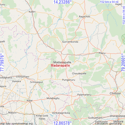
Madanapalle GPS coordinates[2]
13° 33' 1.08" North, 78° 30' 10.368" East
| Map corner | latitude | longitude |
|---|---|---|
| Upper-left | 14.23286°, | 77.79976° |
| Center: | 13.5503°, | 78.50288° |
| Lower-right: | 12.86578°, | 79.20601° |
| Map W x H: | 152×152 km | = 94.4×94.4mi |
| max Lat: | 34.9274° ⇑84.3% North |
| Madanapalle: | 13.5503° |
| min Lat: | ⇓15.7% South 8.09008° |
| min Long | Madanapalle | max Long |
| 68.82655° | 78.50288° | 96.81° |
| W 54.2%⇐ | ⇒45.8% E |
Elevation
Elevation of Madanapalle is 694 m = 2277 ft, and this is 398.4 m = 1307 ft above average elevation for this country.
| Max E: |
3681 m = 12077 ft | 7.7% |
| Madanapalle | 694 m 2277 ft | |
| Avg. | 295.6 m = 970 ft | |
Min E: |
1 m = 3 ft | 92.3% |
See also: Madanapalle elevation on elevation.city.
Geographical zone
Madanapalle is located in North Torrid zone (between Equator and Tropic of Cancer). Distance of this Northern Tropic circle is 1099.3 km =683.1 mi to North.| Distance of | km | miles | from Madanapalle |
|---|---|---|---|
| North Pole | 8500.4 | 5281.9 | to North |
| Arctic Circle | 5894.5 | 3662.7 | to North |
| Tropic Cancer | 1099.3 | 683.1 | to North |
| Equator | 1506.7 | 936.2 | to South |


Nearby cities:
15 places around Madanapalle: (largest is in red/bold)
• Bangarapet
71.4 km =44.4 mi,  209°
209°
• Chintāmani
51.5 km =32 mi,  251°
251°
• Chittoor
74.4 km =46.2 mi,  120°
120°
• Gudiyatham
78.3 km =48.7 mi,  149°
149°
• Kadiri
72.6 km =45.1 mi,  329°
329°
• Kolār
61.1 km =38 mi,  221°
221°
• Mulbāgal
44.6 km =27.7 mi,  195°
195°
• Palmaner
47.1 km =29.3 mi, 145°
• Peranāmpattu
72.4 km =45 mi,  161°
161°
• Punganūru
21.7 km =13.5 mi, 159°
• Pākāla
67.1 km =41.7 mi,  99°
99°
• Robertsonpet
70.5 km =43.8 mi, 200°
• Rāyachoti
62.4 km =38.8 mi,  25°
25°
• Sidlaghatta
71.3 km =44.3 mi,  255°
255°
• Srīnivāspur
39.3 km =24.4 mi,  233°
233°
Sources, notices
• [Note1] Compared only with cities in India existing in our database
• [Src1] Map data: © OpenStreetMap contributors (CC-BY-SA)
• [Src2] Other city data from geonames.org with taken over terms of usage.
• [Src3] Geographical zone / Annual Mean Temperature by Robert A. Rohde @ Wikipedia
