Tirodi geodata
Tirodi (Madhya Pradesh) is a populated place; located in India in Asia/Kolkata (GMT+5.5) time zone. With population of 8,870 people, there are 3051 cities with bigger population in this country. Compared to other cities in India, 58.1% of cities are located further ↑North; 65.8% of cities are located further ←West and 70.5% of cities have lower elevation than Tirodi. Note1


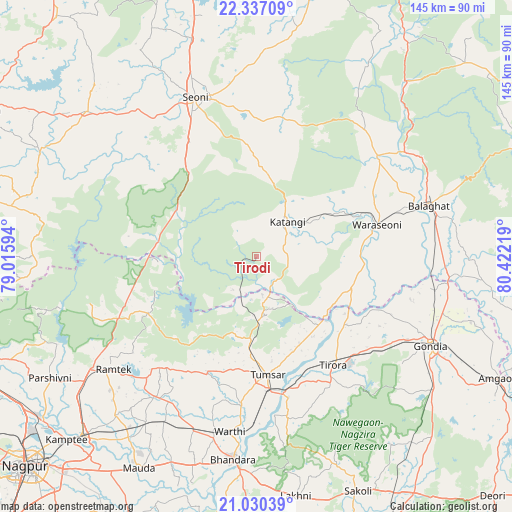
Tirodi GPS coordinates[2]
21° 41' 6.792" North, 79° 43' 8.616" East
| Map corner | latitude | longitude |
|---|---|---|
| Upper-left | 22.33709°, | 79.01594° |
| Center: | 21.68522°, | 79.71906° |
| Lower-right: | 21.03039°, | 80.42219° |
| Map W x H: | 145.3×145.3 km | = 90.3×90.3mi |
| max Lat: | 34.9274° ⇑58.1% North |
| Tirodi: | 21.68522° |
| min Lat: | ⇓41.9% South 8.09008° |
| min Long | Tirodi | max Long |
| 68.82655° | 79.71906° | 96.81° |
| W 65.8%⇐ | ⇒34.2% E |
Elevation
Elevation of Tirodi is 332 m = 1089 ft, and this is 36.4 m = 119 ft above average elevation for this country.
| Max E: |
3681 m = 12077 ft | 29.5% |
| Tirodi | 332 m 1089 ft | |
| Avg. | 295.6 m = 970 ft | |
Min E: |
1 m = 3 ft | 70.5% |
See also: India elevation on elevation.city.
Geographical zone
Tirodi is located in North Torrid zone (between Equator and Tropic of Cancer). Distance of this Northern Tropic circle is 194.7 km =121 mi to North.| Distance of | km | miles | from Tirodi |
|---|---|---|---|
| North Pole | 7595.9 | 4719.9 | to North |
| Arctic Circle | 4990 | 3100.6 | to North |
| Tropic Cancer | 194.7 | 121 | to North |
| Equator | 2411.2 | 1498.2 | to South |


Nearby cities:
15 places around Tirodi: (largest is in red/bold)
• Barghāt
38.4 km =23.9 mi,  2°
2°
• Bhandāra
57.9 km =36 mi,  187°
187°
• Bālāghāt
50.6 km =31.4 mi,  73°
73°
• Chicholi
24.1 km =15 mi,  184°
184°
• Gondiā
54.9 km =34.1 mi,  117°
117°
• Hīrāpur Hamesha
16 km =9.9 mi,  154°
154°
• Katangi
13.3 km =8.3 mi,  42°
42°
• Korādi
80 km =49.7 mi,  232°
232°
• Kāmthi
75.1 km =46.7 mi, 225°
• Kāndri
54.4 km =33.8 mi,  237°
237°
• Mansar
57 km =35.4 mi, 235°
• Rāmtek
51.8 km =32.2 mi, 231°
• Seoni
47.7 km =29.6 mi,  338°
338°
• Tumsar
33.6 km =20.9 mi, 177°
• Wārāseonī
34.5 km =21.4 mi,  75°
75°
Sources, notices
• [Note1] Compared only with cities in India existing in our database
• [Src1] Map data: © OpenStreetMap contributors (CC-BY-SA)
• [Src2] Other city data from geonames.org with taken over terms of usage.
• [Src3] Geographical zone / Annual Mean Temperature by Robert A. Rohde @ Wikipedia
