Chechat geodata
Chechat (Rajasthan) is a populated place; located in India in Asia/Kolkata (GMT+5.5) time zone. With population of 11,138 people, there are 2821 cities with bigger population in this country. Compared to other cities in India, 62.2% of cities are located further ↓South; 74.9% of cities are located further →East and 70.6% of cities have lower elevation than Chechat. Note1


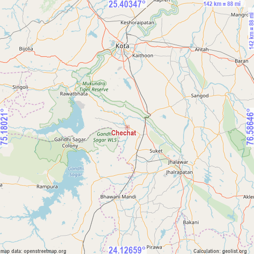
Chechat GPS coordinates[2]
24° 46' 0.012" North, 75° 52' 59.988" East
| Map corner | latitude | longitude |
|---|---|---|
| Upper-left | 25.40347°, | 75.18021° |
| Center: | 24.76667°, | 75.88333° |
| Lower-right: | 24.12659°, | 76.58646° |
| Map W x H: | 142×142 km | = 88.2×88.2mi |
| max Lat: | 34.9274° ⇑37.8% North |
| Chechat: | 24.76667° |
| min Lat: | ⇓62.2% South 8.09008° |
| min Long | Chechat | max Long |
| 68.82655° | 75.88333° | 96.81° |
| W 25.1%⇐ | ⇒74.9% E |
Elevation
Elevation of Chechat is 333 m = 1093 ft, and this is 37.4 m = 123 ft above average elevation for this country.
| Max E: |
3681 m = 12077 ft | 29.4% |
| Chechat | 333 m 1093 ft | |
| Avg. | 295.6 m = 970 ft | |
Min E: |
1 m = 3 ft | 70.6% |
See also: India elevation on elevation.city.
Geographical zone
Chechat is located in North temperate zone (between Tropic of Cancer and the Arctic Circle). Distance of this Northern Tropic circle is 147.9 km =91.9 mi to South.| Distance of | km | miles | from Chechat |
|---|---|---|---|
| North Pole | 7253.3 | 4507 | to North |
| Arctic Circle | 4647.4 | 2887.8 | to North |
| Tropic Cancer | 147.9 | 91.9 | to South |
| Equator | 2753.8 | 1711.1 | to South |


Nearby cities:
15 places around Chechat: (largest is in red/bold)
• Anta
59.8 km =37.2 mi,  44°
44°
• Bhawāniganj
39.3 km =24.4 mi,  187°
187°
• Bhānpura
31.4 km =19.5 mi,  206°
206°
• Jhālrapātan
38.4 km =23.9 mi,  130°
130°
• Jhālāwār
34.2 km =21.3 mi,  123°
123°
• Keshorai Pātan
58.8 km =36.5 mi,  5°
5°
• Khānpur
51.9 km =32.2 mi,  94°
94°
• Kota
46.5 km =28.9 mi,  354°
354°
• Rāmganj Mandi
14.7 km =9.1 mi,  155°
155°
• Rāmpura
55.8 km =34.7 mi,  233°
233°
• Rāwatbhāta
34.5 km =21.4 mi,  301°
301°
• Sangod
44.4 km =27.6 mi,  66°
66°
• Suket
20.9 km =13 mi, 129°
• Sunel
44.7 km =27.8 mi,  170°
170°
• Udpura
10 km =6.2 mi,  111°
111°
Sources, notices
• [Note1] Compared only with cities in India existing in our database
• [Src1] Map data: © OpenStreetMap contributors (CC-BY-SA)
• [Src2] Other city data from geonames.org with taken over terms of usage.
• [Src3] Geographical zone / Annual Mean Temperature by Robert A. Rohde @ Wikipedia
