Rāwatbhāta geodata
Rāwatbhāta (Rajasthan) is a populated place; located in India in Asia/Kolkata (GMT+5.5) time zone. With population of 36,872 people, there are 1190 cities with bigger population in this country. Compared to other cities in India, 63.1% of cities are located further ↓South; 77.7% of cities are located further →East and 73.5% of cities have lower elevation than Rāwatbhāta. Note1


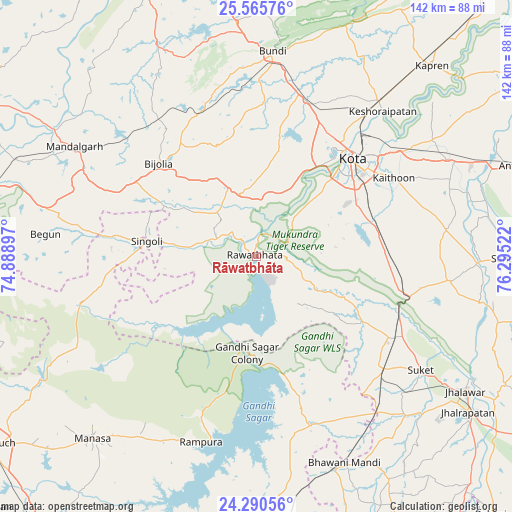
Rāwatbhāta GPS coordinates[2]
24° 55' 47.316" North, 75° 35' 31.524" East
| Map corner | latitude | longitude |
|---|---|---|
| Upper-left | 25.56576°, | 74.88897° |
| Center: | 24.92981°, | 75.59209° |
| Lower-right: | 24.29056°, | 76.29522° |
| Map W x H: | 141.8×141.8 km | = 88.1×88.1mi |
| max Lat: | 34.9274° ⇑36.9% North |
| Rāwatbhāta: | 24.92981° |
| min Lat: | ⇓63.1% South 8.09008° |
| min Long | Rāwatbhāta | max Long |
| 68.82655° | 75.59209° | 96.81° |
| W 22.3%⇐ | ⇒77.7% E |
Elevation
Elevation of Rāwatbhāta is 367 m = 1204 ft, and this is 71.4 m = 234 ft above average elevation for this country.
| Max E: |
3681 m = 12077 ft | 26.5% |
| Rāwatbhāta | 367 m 1204 ft | |
| Avg. | 295.6 m = 970 ft | |
Min E: |
1 m = 3 ft | 73.5% |
See also: India elevation on elevation.city.
Geographical zone
Rāwatbhāta is located in North temperate zone (between Tropic of Cancer and the Arctic Circle). Distance of this Northern Tropic circle is 166 km =103.1 mi to South.| Distance of | km | miles | from Rāwatbhāta |
|---|---|---|---|
| North Pole | 7235.1 | 4495.7 | to North |
| Arctic Circle | 4629.2 | 2876.5 | to North |
| Tropic Cancer | 166 | 103.1 | to South |
| Equator | 2771.9 | 1722.4 | to South |


Nearby cities:
15 places around Rāwatbhāta: (largest is in red/bold)
• Begūn
60 km =37.3 mi,  275°
275°
• Bhawāniganj
62.2 km =38.6 mi,  156°
156°
• Bhānpura
48.9 km =30.4 mi, 161°
• Borkhera
65.9 km =40.9 mi,  4°
4°
• Būndi
56.7 km =35.2 mi, 4°
• Chechat
34.5 km =21.4 mi,  121°
121°
• Keshorai Pātan
53.4 km =33.2 mi,  40°
40°
• Kota
37.5 km =23.3 mi, 41°
• Māndalgarh
60 km =37.3 mi,  299°
299°
• Ratangarh
49.6 km =30.8 mi,  255°
255°
• Rāmganj Mandi
47.4 km =29.5 mi,  131°
131°
• Rāmpura
53.7 km =33.4 mi,  196°
196°
• Singoli
29.7 km =18.5 mi, 277°
• Suket
55.3 km =34.4 mi, 124°
• Udpura
44.4 km =27.6 mi, 119°
Sources, notices
• [Note1] Compared only with cities in India existing in our database
• [Src1] Map data: © OpenStreetMap contributors (CC-BY-SA)
• [Src2] Other city data from geonames.org with taken over terms of usage.
• [Src3] Geographical zone / Annual Mean Temperature by Robert A. Rohde @ Wikipedia
