Bhānpura geodata
Bhānpura (Madhya Pradesh) is a populated place; located in India in Asia/Kolkata (GMT+5.5) time zone. With population of 17,082 people, there are 2276 cities with bigger population in this country. Compared to other cities in India, 60.7% of cities are located further ↓South; 76.3% of cities are located further →East and 76% of cities have lower elevation than Bhānpura. Note1


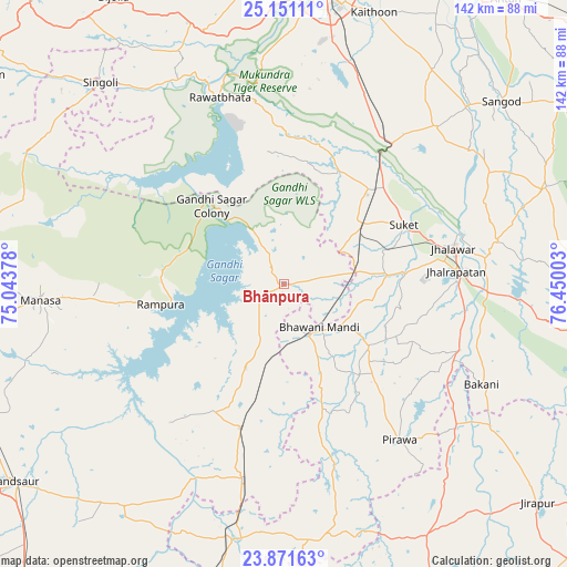
Bhānpura GPS coordinates[2]
24° 30' 46.8" North, 75° 44' 48.84" East
| Map corner | latitude | longitude |
|---|---|---|
| Upper-left | 25.15111°, | 75.04378° |
| Center: | 24.513°, | 75.7469° |
| Lower-right: | 23.87163°, | 76.45003° |
| Map W x H: | 142.3×142.3 km | = 88.4×88.4mi |
| max Lat: | 34.9274° ⇑39.3% North |
| Bhānpura: | 24.513° |
| min Lat: | ⇓60.7% South 8.09008° |
| min Long | Bhānpura | max Long |
| 68.82655° | 75.7469° | 96.81° |
| W 23.7%⇐ | ⇒76.3% E |
Elevation
Elevation of Bhānpura is 399 m = 1309 ft, and this is 103.4 m = 339 ft above average elevation for this country.
| Max E: |
3681 m = 12077 ft | 24% |
| Bhānpura | 399 m 1309 ft | |
| Avg. | 295.6 m = 970 ft | |
Min E: |
1 m = 3 ft | 76% |
See also: India elevation on elevation.city.
Geographical zone
Bhānpura is located in North temperate zone (between Tropic of Cancer and the Arctic Circle). Distance of this Northern Tropic circle is 119.7 km =74.4 mi to South.| Distance of | km | miles | from Bhānpura |
|---|---|---|---|
| North Pole | 7281.5 | 4524.5 | to North |
| Arctic Circle | 4675.6 | 2905.3 | to North |
| Tropic Cancer | 119.7 | 74.4 | to South |
| Equator | 2725.6 | 1693.6 | to South |


Nearby cities:
15 places around Bhānpura: (largest is in red/bold)
• Bakāni
55.7 km =34.6 mi,  116°
116°
• Bhawāniganj
14 km =8.7 mi,  140°
140°
• Chechat
31.4 km =19.5 mi,  26°
26°
• Jhālrapātan
43.2 km =26.8 mi,  85°
85°
• Jhālāwār
43.3 km =26.9 mi,  77°
77°
• Manāsa
61.4 km =38.2 mi,  266°
266°
• Pirāwa
48.9 km =30.4 mi, 144°
• Rāmganj Mandi
24.8 km =15.4 mi,  53°
53°
• Rāmpura
31.5 km =19.6 mi,  260°
260°
• Rāwatbhāta
48.9 km =30.4 mi,  341°
341°
• Shāmgarh
37.7 km =23.4 mi,  196°
196°
• Singoli
67.7 km =42.1 mi,  318°
318°
• Suket
33.3 km =20.7 mi,  63°
63°
• Sunel
26.5 km =16.5 mi,  126°
126°
• Udpura
33.7 km =20.9 mi,  43°
43°
Sources, notices
• [Note1] Compared only with cities in India existing in our database
• [Src1] Map data: © OpenStreetMap contributors (CC-BY-SA)
• [Src2] Other city data from geonames.org with taken over terms of usage.
• [Src3] Geographical zone / Annual Mean Temperature by Robert A. Rohde @ Wikipedia
