Rāmganj Mandi geodata
Rāmganj Mandi (Rajasthan) is a populated place; located in India in Asia/Kolkata (GMT+5.5) time zone. With population of 35,754 people, there are 1212 cities with bigger population in this country. Compared to other cities in India, 61.5% of cities are located further ↓South; 74.2% of cities are located further →East and 73.1% of cities have lower elevation than Rāmganj Mandi. Note1


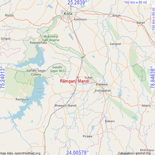
Rāmganj Mandi GPS coordinates[2]
24° 38' 47.328" North, 75° 56' 35.7" East
| Map corner | latitude | longitude |
|---|---|---|
| Upper-left | 25.2839°, | 75.24013° |
| Center: | 24.64648°, | 75.94325° |
| Lower-right: | 24.00579°, | 76.64638° |
| Map W x H: | 142.1×142.1 km | = 88.3×88.3mi |
| max Lat: | 34.9274° ⇑38.5% North |
| Rāmganj Mandi: | 24.64648° |
| min Lat: | ⇓61.5% South 8.09008° |
| min Long | Rāmganj Mandi | max Long |
| 68.82655° | 75.94325° | 96.81° |
| W 25.8%⇐ | ⇒74.2% E |
Elevation
Elevation of Rāmganj Mandi is 362 m = 1188 ft, and this is 66.4 m = 218 ft above average elevation for this country.
| Max E: |
3681 m = 12077 ft | 26.9% |
| Rāmganj Mandi | 362 m 1188 ft | |
| Avg. | 295.6 m = 970 ft | |
Min E: |
1 m = 3 ft | 73.1% |
See also: India elevation on elevation.city.
Geographical zone
Rāmganj Mandi is located in North temperate zone (between Tropic of Cancer and the Arctic Circle). Distance of this Northern Tropic circle is 134.5 km =83.6 mi to South.| Distance of | km | miles | from Rāmganj Mandi |
|---|---|---|---|
| North Pole | 7266.6 | 4515.3 | to North |
| Arctic Circle | 4660.7 | 2896 | to North |
| Tropic Cancer | 134.5 | 83.6 | to South |
| Equator | 2740.4 | 1702.8 | to South |


Nearby cities:
15 places around Rāmganj Mandi: (largest is in red/bold)
• Bakāni
49.9 km =31 mi,  143°
143°
• Bhawāniganj
27.9 km =17.3 mi,  203°
203°
• Bhānpura
24.8 km =15.4 mi,  233°
233°
• Chechat
14.7 km =9.1 mi,  335°
335°
• Jhālrapātan
25.9 km =16.1 mi,  116°
116°
• Jhālāwār
23.1 km =14.4 mi,  103°
103°
• Khānpur
46.7 km =29 mi,  78°
78°
• Pirāwa
55.3 km =34.4 mi,  171°
171°
• Rāmpura
54.7 km =34 mi,  248°
248°
• Rāwatbhāta
47.4 km =29.5 mi,  311°
311°
• Sangod
46.6 km =29 mi,  47°
47°
• Shāmgarh
59.5 km =37 mi,  211°
211°
• Suket
9.9 km =6.2 mi,  90°
90°
• Sunel
30.7 km =19.1 mi,  177°
177°
• Udpura
10.2 km =6.3 mi,  18°
18°
Sources, notices
• [Note1] Compared only with cities in India existing in our database
• [Src1] Map data: © OpenStreetMap contributors (CC-BY-SA)
• [Src2] Other city data from geonames.org with taken over terms of usage.
• [Src3] Geographical zone / Annual Mean Temperature by Robert A. Rohde @ Wikipedia
