Rāmnagar geodata
Rāmnagar (Uttar Pradesh) is a populated place; located in India in Asia/Kolkata (GMT+5.5) time zone. With population of 13,490 people, there are 2615 cities with bigger population in this country. Compared to other cities in India, 79.1% of cities are located further ↓South; 74.3% of cities are located further ←West and 65.2% of cities have higher elevation than Rāmnagar. Note1


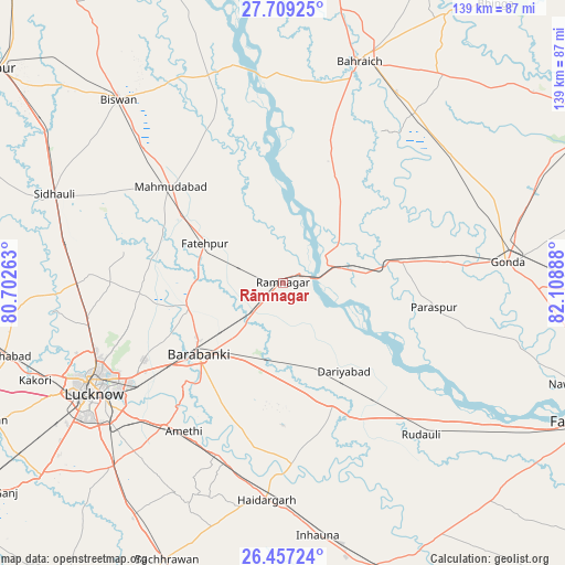
Rāmnagar GPS coordinates[2]
27° 5' 5.964" North, 81° 24' 20.7" East
| Map corner | latitude | longitude |
|---|---|---|
| Upper-left | 27.70925°, | 80.70263° |
| Center: | 27.08499°, | 81.40575° |
| Lower-right: | 26.45724°, | 82.10888° |
| Map W x H: | 139.2×139.2 km | = 86.5×86.5mi |
| max Lat: | 34.9274° ⇑20.9% North |
| Rāmnagar: | 27.08499° |
| min Lat: | ⇓79.1% South 8.09008° |
| min Long | Rāmnagar | max Long |
| 68.82655° | 81.40575° | 96.81° |
| W 74.3%⇐ | ⇒25.7% E |
Elevation
Elevation of Rāmnagar is 119 m = 390 ft, and this is 176.6 m = 579 ft below average elevation for this country.
| Max E: |
3681 m = 12077 ft | 65.2% |
| Avg. | 295.6 m = 970 ft | |
| Rāmnagar | 119 m = 390 ft | |
Min E: |
1 m = 3 ft | 34.8% |
See also: India elevation on elevation.city.
Geographical zone
Rāmnagar is located in North temperate zone (between Tropic of Cancer and the Arctic Circle). Distance of this Northern Tropic circle is 405.6 km =252 mi to South.| Distance of | km | miles | from Rāmnagar |
|---|---|---|---|
| North Pole | 6995.5 | 4346.8 | to North |
| Arctic Circle | 4389.6 | 2727.6 | to North |
| Tropic Cancer | 405.6 | 252 | to South |
| Equator | 3011.6 | 1871.3 | to South |


Nearby cities:
15 places around Rāmnagar: (largest is in red/bold)
• Bahraigh
57.5 km =35.7 mi,  18°
18°
• Colonelganj
29.5 km =18.3 mi,  79°
79°
• Dewā
24.3 km =15.1 mi,  257°
257°
• Fatehpur
21.6 km =13.4 mi,  296°
296°
• Gondā City
54.4 km =33.8 mi, 84°
• Goshāīnganj
46 km =28.6 mi,  219°
219°
• Itaunja
50.4 km =31.3 mi,  269°
269°
• Jarwal
16 km =9.9 mi,  57°
57°
• Lucknow
55.1 km =34.2 mi,  240°
240°
• Mahmudābād
36.6 km =22.7 mi,  308°
308°
• Nagrām
58.1 km =36.1 mi,  206°
206°
• Nawābganj
26.7 km =16.6 mi,  230°
230°
• Satrikh
32.5 km =20.2 mi, 219°
• Tikaitnagar
22.1 km =13.7 mi,  134°
134°
• Zaidpur
29.2 km =18.1 mi,  195°
195°
Sources, notices
• [Note1] Compared only with cities in India existing in our database
• [Src1] Map data: © OpenStreetMap contributors (CC-BY-SA)
• [Src2] Other city data from geonames.org with taken over terms of usage.
• [Src3] Geographical zone / Annual Mean Temperature by Robert A. Rohde @ Wikipedia
