Colonelganj geodata
Colonelganj (Uttar Pradesh) is a populated place; located in India in Asia/Kolkata (GMT+5.5) time zone. With population of 25,503 people, there are 1666 cities with bigger population in this country. Compared to other cities in India, 79.5% of cities are located further ↓South; 75.6% of cities are located further ←West and 66.4% of cities have higher elevation than Colonelganj. Note1


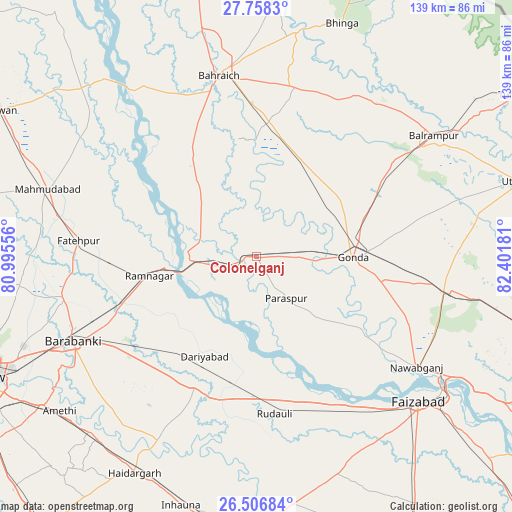
Colonelganj GPS coordinates[2]
27° 8' 3.552" North, 81° 41' 55.248" East
| Map corner | latitude | longitude |
|---|---|---|
| Upper-left | 27.7583°, | 80.99556° |
| Center: | 27.13432°, | 81.69868° |
| Lower-right: | 26.50684°, | 82.40181° |
| Map W x H: | 139.1×139.2 km | = 86.4×86.5mi |
| max Lat: | 34.9274° ⇑20.5% North |
| Colonelganj: | 27.13432° |
| min Lat: | ⇓79.5% South 8.09008° |
| min Long | Colonelganj | max Long |
| 68.82655° | 81.69868° | 96.81° |
| W 75.6%⇐ | ⇒24.4% E |
Elevation
Elevation of Colonelganj is 110 m = 361 ft, and this is 185.6 m = 609 ft below average elevation for this country.
| Max E: |
3681 m = 12077 ft | 66.4% |
| Avg. | 295.6 m = 970 ft | |
| Colonelganj | 110 m = 361 ft | |
Min E: |
1 m = 3 ft | 33.6% |
See also: India elevation on elevation.city.
Geographical zone
Colonelganj is located in North temperate zone (between Tropic of Cancer and the Arctic Circle). Distance of this Northern Tropic circle is 411.1 km =255.4 mi to South.| Distance of | km | miles | from Colonelganj |
|---|---|---|---|
| North Pole | 6990 | 4343.4 | to North |
| Arctic Circle | 4384.1 | 2724.2 | to North |
| Tropic Cancer | 411.1 | 255.4 | to South |
| Equator | 3017.1 | 1874.7 | to South |


Nearby cities:
15 places around Colonelganj: (largest is in red/bold)
• Bahraigh
50 km =31.1 mi,  348°
348°
• Balrāmpur
58.2 km =36.2 mi,  55°
55°
• Dewā
53.8 km =33.4 mi,  258°
258°
• Fatehpur
48.5 km =30.1 mi,  275°
275°
• Gondā City
25.2 km =15.7 mi,  90°
90°
• Ikauna
51.6 km =32.1 mi,  31°
31°
• Jarwal
15.8 km =9.8 mi, 281°
• Katra
52.7 km =32.7 mi,  37°
37°
• Khargupur
39.3 km =24.4 mi,  46°
46°
• Mankāpur
53.3 km =33.1 mi,  99°
99°
• Nawābganj
53.1 km =33 mi,  124°
124°
• Nawābganj
54.4 km =33.8 mi,  245°
245°
• Rāmnagar
29.5 km =18.3 mi, 259°
• Tikaitnagar
24.7 km =15.3 mi,  212°
212°
• Zaidpur
49.8 km =30.9 mi,  227°
227°
Sources, notices
• [Note1] Compared only with cities in India existing in our database
• [Src1] Map data: © OpenStreetMap contributors (CC-BY-SA)
• [Src2] Other city data from geonames.org with taken over terms of usage.
• [Src3] Geographical zone / Annual Mean Temperature by Robert A. Rohde @ Wikipedia
