Itaunja geodata
Itaunja (Uttar Pradesh) is a populated place; located in India in Asia/Kolkata (GMT+5.5) time zone. With population of 6,726 people, there are 3231 cities with bigger population in this country. Compared to other cities in India, 79.1% of cities are located further ↓South; 72.6% of cities are located further ←West and 63.5% of cities have higher elevation than Itaunja. Note1


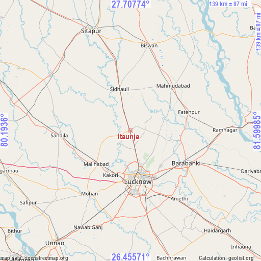
Itaunja GPS coordinates[2]
27° 5' 0.492" North, 80° 53' 48.192" East
| Map corner | latitude | longitude |
|---|---|---|
| Upper-left | 27.70774°, | 80.1936° |
| Center: | 27.08347°, | 80.89672° |
| Lower-right: | 26.45571°, | 81.59985° |
| Map W x H: | 139.2×139.2 km | = 86.5×86.5mi |
| max Lat: | 34.9274° ⇑20.9% North |
| Itaunja: | 27.08347° |
| min Lat: | ⇓79.1% South 8.09008° |
| min Long | Itaunja | max Long |
| 68.82655° | 80.89672° | 96.81° |
| W 72.6%⇐ | ⇒27.4% E |
Elevation
Elevation of Itaunja is 129 m = 423 ft, and this is 166.6 m = 547 ft below average elevation for this country.
| Max E: |
3681 m = 12077 ft | 63.5% |
| Avg. | 295.6 m = 970 ft | |
| Itaunja | 129 m = 423 ft | |
Min E: |
1 m = 3 ft | 36.5% |
See also: India elevation on elevation.city.
Geographical zone
Itaunja is located in North temperate zone (between Tropic of Cancer and the Arctic Circle). Distance of this Northern Tropic circle is 405.5 km =252 mi to South.| Distance of | km | miles | from Itaunja |
|---|---|---|---|
| North Pole | 6995.7 | 4346.9 | to North |
| Arctic Circle | 4389.8 | 2727.7 | to North |
| Tropic Cancer | 405.5 | 252 | to South |
| Equator | 3011.4 | 1871.2 | to South |


Nearby cities:
15 places around Itaunja: (largest is in red/bold)
• Aurās
42.9 km =26.7 mi,  243°
243°
• Biswān
46.9 km =29.1 mi,  12°
12°
• Dewā
27.3 km =17 mi,  101°
101°
• Fatehpur
32.6 km =20.3 mi,  72°
72°
• Goshāīnganj
40.8 km =25.4 mi,  149°
149°
• Kākori
26.4 km =16.4 mi,  204°
204°
• Lucknow
27.3 km =17 mi,  174°
174°
• Mahmudābād
31.9 km =19.8 mi,  43°
43°
• Malīhābād
25.7 km =16 mi,  225°
225°
• Mohān
40.3 km =25 mi,  213°
213°
• Nawābganj
34.3 km =21.3 mi,  119°
119°
• Rāmnagar
50.4 km =31.3 mi,  89°
89°
• Sandīla
37.8 km =23.5 mi,  267°
267°
• Satrikh
38.6 km =24 mi,  129°
129°
• Sidhaulī
22.9 km =14.2 mi,  344°
344°
Sources, notices
• [Note1] Compared only with cities in India existing in our database
• [Src1] Map data: © OpenStreetMap contributors (CC-BY-SA)
• [Src2] Other city data from geonames.org with taken over terms of usage.
• [Src3] Geographical zone / Annual Mean Temperature by Robert A. Rohde @ Wikipedia
