Bahraigh geodata
Bahraigh (Uttar Pradesh) is a populated place; located in India in Asia/Kolkata (GMT+5.5) time zone. With population of 182,218 people, there are 233 cities with bigger population in this country. Compared to other cities in India, 82.4% of cities are located further ↓South; 75.1% of cities are located further ←West and 64% of cities have higher elevation than Bahraigh. Note1


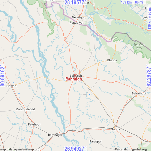
Bahraigh GPS coordinates[2]
27° 34' 27.444" North, 81° 35' 41.064" East
| Map corner | latitude | longitude |
|---|---|---|
| Upper-left | 28.19577°, | 80.89162° |
| Center: | 27.57429°, | 81.59474° |
| Lower-right: | 26.94927°, | 82.29787° |
| Map W x H: | 138.6×138.6 km | = 86.1×86.1mi |
| max Lat: | 34.9274° ⇑17.6% North |
| Bahraigh: | 27.57429° |
| min Lat: | ⇓82.4% South 8.09008° |
| min Long | Bahraigh | max Long |
| 68.82655° | 81.59474° | 96.81° |
| W 75.1%⇐ | ⇒24.9% E |
Elevation
Elevation of Bahraigh is 127 m = 417 ft, and this is 168.6 m = 553 ft below average elevation for this country.
| Max E: |
3681 m = 12077 ft | 64% |
| Avg. | 295.6 m = 970 ft | |
| Bahraigh | 127 m = 417 ft | |
Min E: |
1 m = 3 ft | 36% |
See also: Bahraigh elevation on elevation.city.
Geographical zone
Bahraigh is located in North temperate zone (between Tropic of Cancer and the Arctic Circle). Distance of this Northern Tropic circle is 460.1 km =285.9 mi to South.| Distance of | km | miles | from Bahraigh |
|---|---|---|---|
| North Pole | 6941.1 | 4313 | to North |
| Arctic Circle | 4335.2 | 2693.8 | to North |
| Tropic Cancer | 460.1 | 285.9 | to South |
| Equator | 3066 | 1905.1 | to South |


Nearby cities:
15 places around Bahraigh: (largest is in red/bold)
• Balrāmpur
60.4 km =37.5 mi,  105°
105°
• Bhinga
36.4 km =22.6 mi,  66°
66°
• Biswān
59.7 km =37.1 mi,  261°
261°
• Colonelganj
50 km =31.1 mi,  168°
168°
• Dhaurahra
68.5 km =42.6 mi,  313°
313°
• Fatehpur
58.6 km =36.4 mi,  220°
220°
• Gondā City
60.6 km =37.7 mi,  144°
144°
• Ikauna
37.2 km =23.1 mi,  97°
97°
• Jarwal
46 km =28.6 mi,  186°
186°
• Katra
43.2 km =26.8 mi, 99°
• Khargupur
44.6 km =27.7 mi,  119°
119°
• Lāharpur
69.8 km =43.4 mi,  282°
282°
• Mahmudābād
56.6 km =35.2 mi,  236°
236°
• Nānpāra
33.6 km =20.9 mi,  343°
343°
• Rāmnagar
57.5 km =35.7 mi,  198°
198°
Sources, notices
• [Note1] Compared only with cities in India existing in our database
• [Src1] Map data: © OpenStreetMap contributors (CC-BY-SA)
• [Src2] Other city data from geonames.org with taken over terms of usage.
• [Src3] Geographical zone / Annual Mean Temperature by Robert A. Rohde @ Wikipedia
