Fatehpur geodata
Fatehpur (Uttar Pradesh) is a populated place; located in India in Asia/Kolkata (GMT+5.5) time zone. With population of 34,010 people, there are 1281 cities with bigger population in this country. Compared to other cities in India, 79.8% of cities are located further ↓South; 73.7% of cities are located further ←West and 63.8% of cities have higher elevation than Fatehpur. Note1


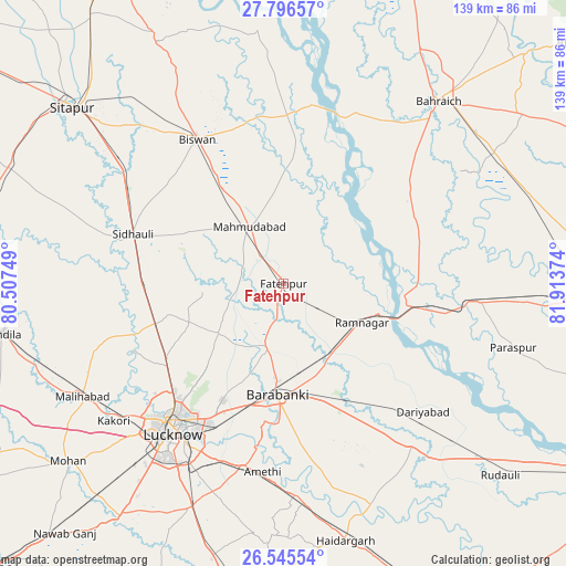
Fatehpur GPS coordinates[2]
27° 10' 22.116" North, 81° 12' 38.196" East
| Map corner | latitude | longitude |
|---|---|---|
| Upper-left | 27.79657°, | 80.50749° |
| Center: | 27.17281°, | 81.21061° |
| Lower-right: | 26.54554°, | 81.91374° |
| Map W x H: | 139.1×139.1 km | = 86.4×86.4mi |
| max Lat: | 34.9274° ⇑20.2% North |
| Fatehpur: | 27.17281° |
| min Lat: | ⇓79.8% South 8.09008° |
| min Long | Fatehpur | max Long |
| 68.82655° | 81.21061° | 96.81° |
| W 73.7%⇐ | ⇒26.3% E |
Elevation
Elevation of Fatehpur is 128 m = 420 ft, and this is 167.6 m = 550 ft below average elevation for this country.
| Max E: |
3681 m = 12077 ft | 63.8% |
| Avg. | 295.6 m = 970 ft | |
| Fatehpur | 128 m = 420 ft | |
Min E: |
1 m = 3 ft | 36.2% |
See also: India elevation on elevation.city.
Geographical zone
Fatehpur is located in North temperate zone (between Tropic of Cancer and the Arctic Circle). Distance of this Northern Tropic circle is 415.4 km =258.1 mi to South.| Distance of | km | miles | from Fatehpur |
|---|---|---|---|
| North Pole | 6985.7 | 4340.7 | to North |
| Arctic Circle | 4379.8 | 2721.5 | to North |
| Tropic Cancer | 415.4 | 258.1 | to South |
| Equator | 3021.3 | 1877.3 | to South |


Nearby cities:
15 places around Fatehpur: (largest is in red/bold)
• Biswān
41.7 km =25.9 mi,  329°
329°
• Colonelganj
48.5 km =30.1 mi,  95°
95°
• Dewā
15.8 km =9.8 mi,  195°
195°
• Goshāīnganj
46.2 km =28.7 mi,  192°
192°
• Itaunja
32.6 km =20.3 mi,  252°
252°
• Jarwal
32.8 km =20.4 mi,  91°
91°
• Kākori
54 km =33.6 mi,  231°
231°
• Lucknow
46.8 km =29.1 mi,  217°
217°
• Mahmudābād
16.1 km =10 mi, 325°
• Nawābganj
26.9 km =16.7 mi,  182°
182°
• Rāmnagar
21.6 km =13.4 mi,  116°
116°
• Satrikh
34.8 km =21.6 mi, 182°
• Sidhaulī
39.1 km =24.3 mi,  288°
288°
• Tikaitnagar
43.3 km =26.9 mi,  125°
125°
• Zaidpur
39.8 km =24.7 mi,  162°
162°
Sources, notices
• [Note1] Compared only with cities in India existing in our database
• [Src1] Map data: © OpenStreetMap contributors (CC-BY-SA)
• [Src2] Other city data from geonames.org with taken over terms of usage.
• [Src3] Geographical zone / Annual Mean Temperature by Robert A. Rohde @ Wikipedia
