Gondā City geodata
Gondā City (Uttar Pradesh) is a populated place; located in India in Asia/Kolkata (GMT+5.5) time zone. With population of 133,583 people, there are 325 cities with bigger population in this country. Compared to other cities in India, 79.5% of cities are located further ↓South; 76.4% of cities are located further ←West and 66% of cities have higher elevation than Gondā City. Note1


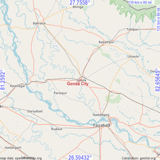
Gondā City GPS coordinates[2]
27° 7' 54.516" North, 81° 57' 11.952" East
| Map corner | latitude | longitude |
|---|---|---|
| Upper-left | 27.7558°, | 81.2502° |
| Center: | 27.13181°, | 81.95332° |
| Lower-right: | 26.50432°, | 82.65645° |
| Map W x H: | 139.2×139.2 km | = 86.5×86.5mi |
| max Lat: | 34.9274° ⇑20.5% North |
| Gondā City: | 27.13181° |
| min Lat: | ⇓79.5% South 8.09008° |
| min Long | Gondā City | max Long |
| 68.82655° | 81.95332° | 96.81° |
| W 76.4%⇐ | ⇒23.6% E |
Elevation
Elevation of Gondā City is 113 m = 371 ft, and this is 182.6 m = 599 ft below average elevation for this country.
| Max E: |
3681 m = 12077 ft | 66% |
| Avg. | 295.6 m = 970 ft | |
| Gondā City | 113 m = 371 ft | |
Min E: |
1 m = 3 ft | 34% |
See also: Gondā City elevation on elevation.city.
Geographical zone
Gondā City is located in North temperate zone (between Tropic of Cancer and the Arctic Circle). Distance of this Northern Tropic circle is 410.9 km =255.3 mi to South.| Distance of | km | miles | from Gondā City |
|---|---|---|---|
| North Pole | 6990.3 | 4343.6 | to North |
| Arctic Circle | 4384.4 | 2724.3 | to North |
| Tropic Cancer | 410.9 | 255.3 | to South |
| Equator | 3016.8 | 1874.6 | to South |


Nearby cities:
15 places around Gondā City: (largest is in red/bold)
• Ajodhya
44.6 km =27.7 mi,  146°
146°
• Bahraigh
60.6 km =37.7 mi,  324°
324°
• Balrāmpur
40.3 km =25 mi,  34°
34°
• Bīkāpur
62.2 km =38.6 mi,  163°
163°
• Colonelganj
25.2 km =15.7 mi,  270°
270°
• Fyzābād
44.2 km =27.5 mi, 153°
• Ikauna
44.4 km =27.6 mi,  2°
2°
• Jarwal
40.9 km =25.4 mi, 274°
• Katra
42.5 km =26.4 mi,  9°
9°
• Khargupur
27.4 km =17 mi, 7°
• Mankāpur
28.8 km =17.9 mi,  107°
107°
• Nawābganj
35.1 km =21.8 mi, 148°
• Rāmnagar
54.4 km =33.8 mi,  264°
264°
• Tikaitnagar
43.6 km =27.1 mi,  241°
241°
• Utraula
50.5 km =31.4 mi,  65°
65°
Sources, notices
• [Note1] Compared only with cities in India existing in our database
• [Src1] Map data: © OpenStreetMap contributors (CC-BY-SA)
• [Src2] Other city data from geonames.org with taken over terms of usage.
• [Src3] Geographical zone / Annual Mean Temperature by Robert A. Rohde @ Wikipedia
