Jarwal geodata
Jarwal (Uttar Pradesh) is a populated place; located in India in Asia/Kolkata (GMT+5.5) time zone. With population of 17,576 people, there are 2228 cities with bigger population in this country. Compared to other cities in India, 79.7% of cities are located further ↓South; 74.9% of cities are located further ←West and 66.2% of cities have higher elevation than Jarwal. Note1


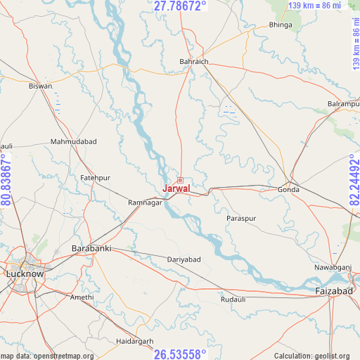
Jarwal GPS coordinates[2]
27° 9' 46.44" North, 81° 32' 30.444" East
| Map corner | latitude | longitude |
|---|---|---|
| Upper-left | 27.78672°, | 80.83867° |
| Center: | 27.1629°, | 81.54179° |
| Lower-right: | 26.53558°, | 82.24492° |
| Map W x H: | 139.1×139.1 km | = 86.4×86.4mi |
| max Lat: | 34.9274° ⇑20.3% North |
| Jarwal: | 27.1629° |
| min Lat: | ⇓79.7% South 8.09008° |
| min Long | Jarwal | max Long |
| 68.82655° | 81.54179° | 96.81° |
| W 74.9%⇐ | ⇒25.1% E |
Elevation
Elevation of Jarwal is 112 m = 367 ft, and this is 183.6 m = 602 ft below average elevation for this country.
| Max E: |
3681 m = 12077 ft | 66.2% |
| Avg. | 295.6 m = 970 ft | |
| Jarwal | 112 m = 367 ft | |
Min E: |
1 m = 3 ft | 33.8% |
See also: India elevation on elevation.city.
Geographical zone
Jarwal is located in North temperate zone (between Tropic of Cancer and the Arctic Circle). Distance of this Northern Tropic circle is 414.3 km =257.4 mi to South.| Distance of | km | miles | from Jarwal |
|---|---|---|---|
| North Pole | 6986.8 | 4341.4 | to North |
| Arctic Circle | 4380.9 | 2722.2 | to North |
| Tropic Cancer | 414.3 | 257.4 | to South |
| Equator | 3020.2 | 1876.7 | to South |


Nearby cities:
15 places around Jarwal: (largest is in red/bold)
• Bahraigh
46 km =28.6 mi,  6°
6°
• Colonelganj
15.8 km =9.8 mi,  101°
101°
• Dewā
39.7 km =24.7 mi,  249°
249°
• Fatehpur
32.8 km =20.4 mi,  271°
271°
• Gondā City
40.9 km =25.4 mi,  94°
94°
• Goshāīnganj
61.5 km =38.2 mi,  224°
224°
• Ikauna
58.8 km =36.5 mi,  45°
45°
• Katra
61.4 km =38.2 mi, 51°
• Khargupur
50.1 km =31.1 mi,  61°
61°
• Mahmudābād
44.3 km =27.5 mi,  288°
288°
• Nawābganj
42.7 km =26.5 mi,  232°
232°
• Rāmnagar
16 km =9.9 mi,  237°
237°
• Satrikh
48 km =29.8 mi, 225°
• Tikaitnagar
24.2 km =15 mi,  174°
174°
• Zaidpur
42.5 km =26.4 mi,  209°
209°
Sources, notices
• [Note1] Compared only with cities in India existing in our database
• [Src1] Map data: © OpenStreetMap contributors (CC-BY-SA)
• [Src2] Other city data from geonames.org with taken over terms of usage.
• [Src3] Geographical zone / Annual Mean Temperature by Robert A. Rohde @ Wikipedia
