Mahmudābād geodata
Mahmudābād (Uttar Pradesh) is a populated place; located in India in Asia/Kolkata (GMT+5.5) time zone. With population of 45,921 people, there are 963 cities with bigger population in this country. Compared to other cities in India, 80.7% of cities are located further ↓South; 73.4% of cities are located further ←West and 63.5% of cities have higher elevation than Mahmudābād. Note1


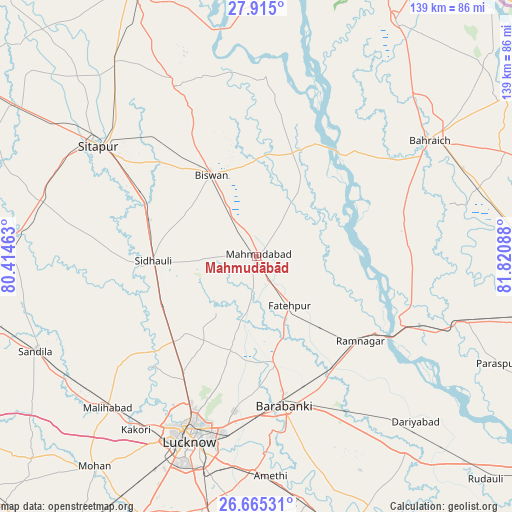
Mahmudābād GPS coordinates[2]
27° 17' 30.876" North, 81° 7' 3.9" East
| Map corner | latitude | longitude |
|---|---|---|
| Upper-left | 27.915°, | 80.41463° |
| Center: | 27.29191°, | 81.11775° |
| Lower-right: | 26.66531°, | 81.82088° |
| Map W x H: | 139×139 km | = 86.4×86.4mi |
| max Lat: | 34.9274° ⇑19.3% North |
| Mahmudābād: | 27.29191° |
| min Lat: | ⇓80.7% South 8.09008° |
| min Long | Mahmudābād | max Long |
| 68.82655° | 81.11775° | 96.81° |
| W 73.4%⇐ | ⇒26.6% E |
Elevation
Elevation of Mahmudābād is 129 m = 423 ft, and this is 166.6 m = 547 ft below average elevation for this country.
| Max E: |
3681 m = 12077 ft | 63.5% |
| Avg. | 295.6 m = 970 ft | |
| Mahmudābād | 129 m = 423 ft | |
Min E: |
1 m = 3 ft | 36.5% |
See also: Mahmudābād elevation on elevation.city.
Geographical zone
Mahmudābād is located in North temperate zone (between Tropic of Cancer and the Arctic Circle). Distance of this Northern Tropic circle is 428.7 km =266.4 mi to South.| Distance of | km | miles | from Mahmudābād |
|---|---|---|---|
| North Pole | 6972.5 | 4332.5 | to North |
| Arctic Circle | 4366.6 | 2713.3 | to North |
| Tropic Cancer | 428.7 | 266.4 | to South |
| Equator | 3034.6 | 1885.6 | to South |


Nearby cities:
15 places around Mahmudābād: (largest is in red/bold)
• Bahraigh
56.6 km =35.2 mi,  56°
56°
• Biswān
25.7 km =16 mi,  332°
332°
• Dewā
28.8 km =17.9 mi,  170°
170°
• Fatehpur
16.1 km =10 mi,  145°
145°
• Itaunja
31.9 km =19.8 mi,  223°
223°
• Jarwal
44.3 km =27.5 mi,  108°
108°
• Khairābād
44.4 km =27.6 mi,  306°
306°
• Lucknow
53.9 km =33.5 mi,  200°
200°
• Lāharpur
50.9 km =31.6 mi,  335°
335°
• Nawābganj
40.9 km =25.4 mi, 168°
• Rāmnagar
36.6 km =22.7 mi,  128°
128°
• Satrikh
48.6 km =30.2 mi, 170°
• Sidhaulī
28 km =17.4 mi,  267°
267°
• Sītāpur
52.4 km =32.6 mi,  304°
304°
• Zaidpur
55.4 km =34.4 mi,  157°
157°
Sources, notices
• [Note1] Compared only with cities in India existing in our database
• [Src1] Map data: © OpenStreetMap contributors (CC-BY-SA)
• [Src2] Other city data from geonames.org with taken over terms of usage.
• [Src3] Geographical zone / Annual Mean Temperature by Robert A. Rohde @ Wikipedia
