Mulbāgal geodata
Mulbāgal (Karnataka) is a populated place; located in India in Asia/Kolkata (GMT+5.5) time zone. With population of 47,462 people, there are 930 cities with bigger population in this country. Compared to other cities in India, 85.5% of cities are located further ↑North; 53% of cities are located further ←West and 94.6% of cities have lower elevation than Mulbāgal. Note1


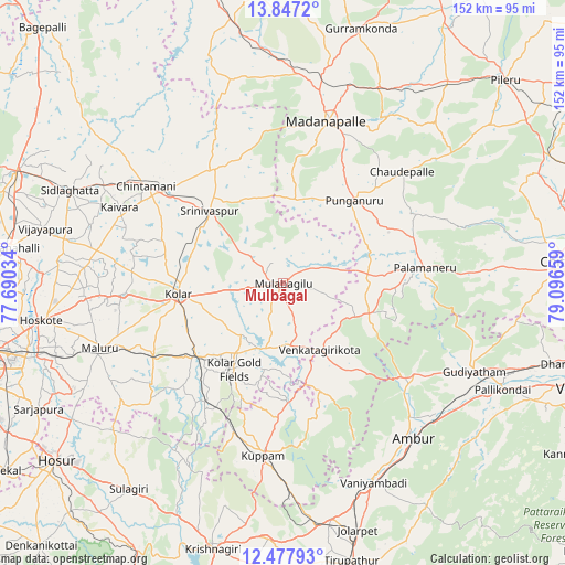
Mulbāgal GPS coordinates[2]
13° 9' 48.672" North, 78° 23' 36.456" East
| Map corner | latitude | longitude |
|---|---|---|
| Upper-left | 13.8472°, | 77.69034° |
| Center: | 13.16352°, | 78.39346° |
| Lower-right: | 12.47793°, | 79.09659° |
| Map W x H: | 152.2×152.3 km | = 94.6×94.6mi |
| max Lat: | 34.9274° ⇑85.5% North |
| Mulbāgal: | 13.16352° |
| min Lat: | ⇓14.5% South 8.09008° |
| min Long | Mulbāgal | max Long |
| 68.82655° | 78.39346° | 96.81° |
| W 53%⇐ | ⇒47% E |
Elevation
Elevation of Mulbāgal is 849 m = 2785 ft, and this is 553.4 m = 1816 ft above average elevation for this country.
| Max E: |
3681 m = 12077 ft | 5.4% |
| Mulbāgal | 849 m 2785 ft | |
| Avg. | 295.6 m = 970 ft | |
Min E: |
1 m = 3 ft | 94.6% |
See also: Mulbāgal elevation on elevation.city.
Geographical zone
Mulbāgal is located in North Torrid zone (between Equator and Tropic of Cancer). Distance of this Northern Tropic circle is 1142.3 km =709.8 mi to North.| Distance of | km | miles | from Mulbāgal |
|---|---|---|---|
| North Pole | 8543.4 | 5308.6 | to North |
| Arctic Circle | 5937.5 | 3689.4 | to North |
| Tropic Cancer | 1142.3 | 709.8 | to North |
| Equator | 1463.6 | 909.4 | to South |


Nearby cities:
15 places around Mulbāgal: (largest is in red/bold)
• Ambur
54.2 km =33.7 mi,  139°
139°
• Bangarapet
30.2 km =18.8 mi,  230°
230°
• Chintāmani
45.4 km =28.2 mi,  305°
305°
• Dasarahalli
61.2 km =38 mi,  263°
263°
• Gudiyatham
57.4 km =35.7 mi,  114°
114°
• Kolār
28.7 km =17.8 mi, 264°
• Kuppam
46.4 km =28.8 mi,  186°
186°
• Madanapalle
44.6 km =27.7 mi,  15°
15°
• Mālūr
52.5 km =32.6 mi,  250°
250°
• Palmaner
38.5 km =23.9 mi,  83°
83°
• Peranāmpattu
43.5 km =27 mi,  125°
125°
• Punganūru
29.7 km =18.5 mi,  40°
40°
• Robertsonpet
26.4 km =16.4 mi,  209°
209°
• Srīnivāspur
27.7 km =17.2 mi, 314°
• Vaniyambadi
58.9 km =36.6 mi,  155°
155°
Sources, notices
• [Note1] Compared only with cities in India existing in our database
• [Src1] Map data: © OpenStreetMap contributors (CC-BY-SA)
• [Src2] Other city data from geonames.org with taken over terms of usage.
• [Src3] Geographical zone / Annual Mean Temperature by Robert A. Rohde @ Wikipedia
