Baikunthpur geodata
Baikunthpur (Chhattisgarh) is a populated place; located in India in Asia/Kolkata (GMT+5.5) time zone. With population of 10,790 people, there are 2857 cities with bigger population in this country. Compared to other cities in India, 53.4% of cities are located further ↓South; 78% of cities are located further ←West and 85.9% of cities have lower elevation than Baikunthpur. Note1


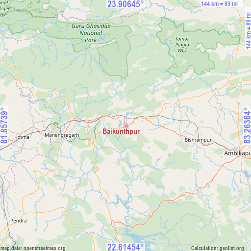
Baikunthpur GPS coordinates[2]
23° 15' 43.416" North, 82° 33' 37.836" East
| Map corner | latitude | longitude |
|---|---|---|
| Upper-left | 23.90645°, | 81.85739° |
| Center: | 23.26206°, | 82.56051° |
| Lower-right: | 22.61454°, | 83.26364° |
| Map W x H: | 143.6×143.6 km | = 89.2×89.2mi |
| max Lat: | 34.9274° ⇑46.6% North |
| Baikunthpur: | 23.26206° |
| min Lat: | ⇓53.4% South 8.09008° |
| min Long | Baikunthpur | max Long |
| 68.82655° | 82.56051° | 96.81° |
| W 78%⇐ | ⇒22% E |
Elevation
Elevation of Baikunthpur is 560 m = 1837 ft, and this is 264.4 m = 867 ft above average elevation for this country.
| Max E: |
3681 m = 12077 ft | 14.1% |
| Baikunthpur | 560 m 1837 ft | |
| Avg. | 295.6 m = 970 ft | |
Min E: |
1 m = 3 ft | 85.9% |
See also: India elevation on elevation.city.
Geographical zone
Baikunthpur is located in North Torrid zone (between Equator and Tropic of Cancer). Distance of this Northern Tropic circle is 19.4 km =12.1 mi to North.| Distance of | km | miles | from Baikunthpur |
|---|---|---|---|
| North Pole | 7420.6 | 4610.9 | to North |
| Arctic Circle | 4814.7 | 2991.7 | to North |
| Tropic Cancer | 19.4 | 12.1 | to North |
| Equator | 2586.5 | 1607.2 | to South |


Nearby cities:
15 places around Baikunthpur: (largest is in red/bold)
• Amarkantak
104.9 km =65.2 mi,  231°
231°
• Ambikāpur
66.8 km =41.5 mi,  103°
103°
• Anūppur
90.6 km =56.3 mi,  258°
258°
• Balrampur
114 km =70.8 mi,  70°
70°
• Bodri
115.8 km =72 mi, 264°
• Burhar
105.2 km =65.4 mi,  267°
267°
• Gaurela
88 km =54.7 mi, 230°
• Katghora
84.5 km =52.5 mi,  181°
181°
• Korba
102.8 km =63.9 mi,  172°
172°
• Kotma
59.8 km =37.2 mi, 263°
• Pasān
59.4 km =36.9 mi,  218°
218°
• Pendra
81.9 km =50.9 mi, 228°
• Ratanpur
115.7 km =71.9 mi,  200°
200°
• Singrauli
104.9 km =65.2 mi,  6°
6°
• Surajpur
31.9 km =19.8 mi, 99°
Sources, notices
• [Note1] Compared only with cities in India existing in our database
• [Src1] Map data: © OpenStreetMap contributors (CC-BY-SA)
• [Src2] Other city data from geonames.org with taken over terms of usage.
• [Src3] Geographical zone / Annual Mean Temperature by Robert A. Rohde @ Wikipedia
